
 Loading more
Page 2
A memorial of the centenary of the church gives information on the early vicars. The first incumbent, Edwin C. Montriou went to Darwen after only a few months, and was succeeded by Edward Parker, who stayed for four years. A longer incumbency was sustained by Dr. Christopher Robinson, from 1850 to 1869: he was a personal friend of the Prime Minister W.E. Gladstone and gave a stained-glass window in memory of his infant son; the transept windows are in turn memorials to him. The organ, built by Messrs Gray and Davison was installed in 1851, initially in the west gallery, and later moved to the south side of the chancel.
Dr. Robinson was succeeded on his death by William Robert Stephens, for a decade, and then by Dr Christopher William Moffatt from 1879 to 1903 who was previously the Anglican chaplain in Brussels. Dr Moffatt had ten children, necessitating extensions to the vicarage which later became dangerous and were demolished in 1952. In his time tubular bells were placed in the belfry, but these were replaced in 1888 by a ring of eight bells by Messrs Taylor of Loughborough, of which the tenor weighed eighteen hundredweight. (These bells now ring every Sunday from St. Silas, Blackburn.) The lectern, in the form of a brass eagle, was given in his memory.
In 1904 Henry Thornton, later a Canon, was appointed by his father who, after 25 years as Bishop of Ballarat, had returned to be vicar at Blackburn and an assistant bishop in Manchester diocese. He lived a life of spartan simplicity and eventually became a missionary in Costa Rica, although he still kept in touch with Holy Trinity. The church's diamond jubilee occurred during his vicariate, and a souvenir booklet records an average attendance of 579 in the Day Schools and 729 in the Sunday School, with 1200 people attending the special service held to mark the anniversary, at which the sermon was preached by his father.
His successor, George S. Perry, who also became a canon at the Cathedral had been Bishop Thornton's curate. He was inducted on 10 May 1910 and remained as vicar for 31 years until his death on 11 August 1941. He was remembered as an active and assiduous worker and a powerful preacher. During his stay the church was twice redecorated, and electric lights installed. A marble pulpit was erected in memory of those members of the parish who did not return from the Great War of 1914-1918, and the grey and black chequered marble of the chancel floor also dates from this time. A new school was begun in 1910, and a number of gifts were made to the church, including some silver.
After a vacancy of a year, Chad Varah was instituted on 15 January 1942: he was vicar at the time of the centenary celebrations and remained at Holy Trinity until 1949. In 1953 he founded the Samaritans. Subsequent vicars were Albert Joseph Gillespie (1949-56), Norman Cowen May (1956-61), John Michael Waters (1963-70) and canon Brian Beaumont (1970-77). Worship at the church ceased in November 1978. A consistory court hearing took place in July 1979 to hear an application for demolition. The church was declared redundant in March 1981 and on 18 May 1984 it was vested in the Redundant Churches Fund. Since that time restoration work has proceeded under the supervision initially of Mr. Donald Buttress of Manchester and subsequently Mr. Michael Bottomley of Kendal.
Exterior
The walls of the church are faced externally with squared masonry: as with other buildings by Sharpe, the local sandstone was used, blending well with the surrounding landscape. The church was designed to have a tower surmounted by a commanding spire which, if it had been built, would have been seen for miles around. At the east end the design included provision for the schools. These were designed to have the outside appearance of four equally-sized chapels, under four parallel gables, comparable to the arrangement at Long Melford in Suffolk. They were demolished in 1962 but their outline can still be discerned on the exterior of the east wall.
The standing structure consists of a west tower, nave, crossing and chancel, all of equal width with north and south aisles of the same length as the nave, but at a lower ceiling height. The transepts, which internally extend only a further half-width beyond the aisles, are discerned more prominently on the exterior because they are built on the same height as the nave. Beyond them the east front is completed by two chapels, of which the south is occupied by the organ. The emphasis, even without the spire, is strongly vertical, and this effect is enhanced by use of narrow lancet windows wherever possible, filled, in chancel and transepts, with excellent stained glass.
The west tower is built in four stages, divided by string courses at three levels which encircle both the walls and the octagonal buttresses at the angles. At the lowest level these buttresses are relieved by further superimposed diagonal buttresses and the walls are broken only by the modestly proportioned west door. At the next stage is a west window of three lights, which introduces the flattened triangular motif which recurs repeatedly elsewhere. There are also small single-light windows in the side walls. The third stage offers a small lancet in each face, with a stone roundel in the west face for a clock (not inserted). The fourth stage has two-light bell openings in each face, separated by a slender buttress, and with moulded hoods terminating in foliate stops. The parapet is straight with two grotesque gargoyles on each face above a moulding decorated with ballflower. Finally, the octagonal buttresses that originate at the foot of the tower continue above the level of the parapet to finish in crocketed pinnacles.
Interior
The interior plan is strictly symmetrical. The tower contains a stone staircase to the west gallery, which extends twelve feet from the west wall; originally there were galleries in the aisles and transepts, but these have been removed, with no loss to the form of the building. Above the west gallery is a window of seven lights let into the wall between church and tower. Unusually, this window contains quatrefoil ornamentation as well as the trefoil found elsewhere in the building.
The nave, twenty-four feet wide, is punctuated by four stone pillars of a dark grain, standing at fifteen-feet centres from each other: they are of a quatrefoil plan and consist of four slender shafts attached to a central core, with mouldings in the arches carrying through the same principles. The north and south aisles are each over half the width of the nave, lending an air of spaciousness to the design, and this impression is aided by the two-light clerestory windows above.
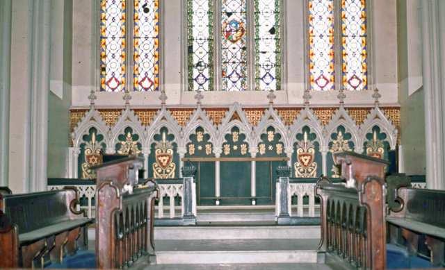
Altar in Holy Trinity Church, 1979
image taken by Adrian Lewis former Curator of Blackburn Museum
Altar in Holy Trinity Church, 1979
image taken by Adrian Lewis former Curator of Blackburn Museum
The crossing, transepts and chancel are dignified by their width and height and by the soaring windows at the east end and in the transepts. The crossing is bounded by four clustered shafts which are of course taller than those of the nave arcades and carry arches of larger dimensions but similar mouldings: at the stops of the mouldings are some carved busts, formerly painted in bright colours but now white, as are the plastered walls. There is a doorway in the centre of each transept, and above each is a main window of five lights, capped by its own trefoil. At the east end, above a run of stone arcading topped by nine cinquefoil arches, each with its own gablet, is a further arrangement of seven lights; the land falls away beyond this point, so that the window was not obstructed by the school building that ran eastwards from this wall. The chancel is of two bays with a plain arch set between the two dividing the choir from the sanctuary. The altar is in place with hangings and is fronted by communion rails in the style of gothic arcading, with octagonal posts each side of the centre opening. There are two fonts: the original one in the south transept octagonal with restrained ballflower decoration; the other of a basic design and supported by pillars from St. Lawrence, Morecambe. The pulpit is octagonal, of polished white veined marble, with a cornice of green marble, and is set on a cluster of colonettes with black traceried panels. The organ originated at the Hanover Square Room in London in 1804, but in its present state it is a two-manual instrument built by Gray and Davidson in 1851 but now has electro-pneumatic action. A small number of pipes survive from 1804.
From the western bay of the chancel there are arches, similar to those in the nave, which open into the north chapel and the south organ chamber; and both these areas communicate by similar arches with the transepts. At the time of the centenary celebrations, lettering (presumably of biblical texts) ran above the stringcourse that surmounts the arches and runs the length of the transepts.
The particular glory of the interior is the ceiling of painted heraldic panels that is placed above chancel, crossing transepts and much of the nave. At this stage the vertical gothic style gives way to a flat ceiling that appears to contradict the strict archaeological accuracy of the rest of the building. There can be, however, no doubt that the ceiling was part of the original design: the contemporary lithograph of the exterior displays an exceptionally shallow pitch of roof that would accord with a flat ceiling below; the offices and families represented show significant correspondence with the original subscribers of 1837 and 1838; and the original listing of arms to be displayed also dates from 1837.
A local heraldic expert, Mr. Christopher Ward, has undertaken extensive research on the arms displayed on the panels, and the information given below is taken from his investigations. There are eighty panels, divided from each other by moulded ribs. The largest, the central square at the crossing, gives the royal arms of Queen Victoria, surrounded by the bearings of Ireland, Wales, Scotland and France, and by eight earlier versions of the royal arms (Edward the Confessor, Henry II, Henry III, Edward III, Henry V, James I, George I and George III), although not all rendered with complete accuracy. The three at the east end of the chancel portray the badges of Lancaster, Tudor and York, and the row of four immediately behind show the arms of the contemporary Archbishop of Canterbury, and the Bishops of Manchester, London and Chester. Another four, placed in corners where the panel is not complete, are imaginary arms with no meaning, and one or two are difficult to interpret. The remainder have all been identified as belonging to local families, many of whom had close connections with the church, and together they offer a fascinating social history of the local dignitaries of the period. Just one or two examples will show the range of contemporary reference.
Dr. J. W. Whittaker, already mentioned, has his arms displayed at no. 26. He married Mary Houghton, eldest daughter of William Feilden (later baronet) of Feniscowles, and his arms are shown at no. 41. The Feilden’s were one of the principal landowners and cotton manufacturers of Blackburn, at a period when the transition from putting out work to home-based weavers to the creation of large-scale factories was taking place. No. 37 relates to another member of the same family, Joseph Feilden of Witton Park, who was High Sheriff of Lancashire in 1818 and M.P. for Blackburn for four years. He married Frances Mary, daughter of the Rev. Streynsham Master, Rector of Croston from 1798 to 1864, whose arms are shown at no. 43. He in turn was the son of Elizabeth Whalley, cousin and heiress of John Whalley, rector of Slaidburn (no. 58). There are coats of arms connected with families or persons at a greater distance: the Parkers of Browsholme and Alkincoates (no’s 25, 42, 54); the Garnetts of Salford and Quernmore (no. 71); the Revd. William Whewell who gave his name to a court at Trinity College, Cambridge (the son of a Lancaster master carpenter) (no. 67), and Colonel le Gendre Nicolas Starkie, D.L, J.P of Huntroyde and Ashton Hall, Lancaster (no. 55). One person could hardly have been more local: John Hargreaves (no. 78) of Larkhill House in Blackburn, was a colonel in the Blackburn Militia and coroner of Blackburn Hundred from 1810 to 1865, as well as being the first town clerk of Blackburn, and he and other members of the family subscribed more than once to the new church.
The Coucher Book of Holy Trinity records that when the first setting of the arms was commissioned, one William Birch was employed. In the 1841 Census he is listed as living, with his wife and five children, at Holme Street, not far from Ainsworth Street, where another painter, Benjamin West, was resident. The second set was ordered from John Brocklehurst of Lord Street, who passed on the work to a Samuel Driver. Some of the panels were taken down and conserved in 1986-9 by Jane Rutherford of Lambourn, Francis W. Downing of Harrogate and Harriet Owen Hughes of Liverpool. They now form the centrepieceof any visit to the church and its surroundings and it is hoped that benefactors will come forward to make possible the conservation of the remaining panels.
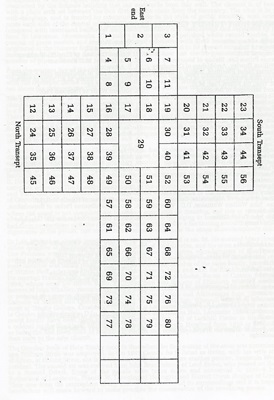
ARMS IN HOLY TRINITY CHURCH, BLACKBURN
ARMS IN HOLY TRINITY CHURCH, BLACKBURN
ARMS IN HOLY TRINITY CHURCH, BLACKBURN
1. Badge of Lancaster
2. Badge of Tudor
3. Badge of York
4. James Prince Lee, Bishop of Manchester
5. William Howley, Archbishop of Canterbury
6. Charles James Bloomfield, Bishop of London
7. John Bird Sumner, Bishop of Chester
8. Rt. Hon. Sir Robert Peel, M.P
9. Lord Montague of Broughton
10. Sir George Warren, Bt. 2nd Baron de Tabley
11. Sir Henry Bold-Hoghton, Bt
12. [Fancy]
13. Pudsey Dawson
14. Rev. W. Thursby of Ormerod
15. Lt. Col. Edward Every-Clayton, J.P
16. France
17. King Edward the Confessor
18. King Henry II
19. Scotland
20. James Nowell Farrington of Worden
21. Rev. Robert Nowell Whittaker, Vicar of Whalley
22. Thomas Greene of Whittington, J.P., M.P for Lancaster
23. [Fancy]
24. Henry Brock-Hollinshead of Billinge Carr
25. Edward Parker of Alkincoates, Colne
26. Rev. John William Whittaker, D. D., Vicar of Blackburn
27. Col. John Talbot Clifton
28. King Henry III
29. Queen Victoria
30. King Edward III
31. Richard Cardwell of King St. Blackburn
32. John Hornby, M. P Blackburn
33. P. Ainsworth
34. John Feilden of Mollington Hall, Cheshire
35. Rev. Robert Hornby MA, Vicar of Walton le Dale 1837-52
36. Richard Willis of Halsnead Park
37. Joseph Feilden of Witton, J.P, D.L, M.P for Blackburn
38. J.H. Ainsworth
39. King Henry V
40. King James I
41. Sir William Feilden, Bt of Feniscowles
42. Robert Townley Parker of Cuerden
43. Rev. Streynsham Master, Rector of Croston
44. Baynes
45. [? Robinson]
46. Major General James Yorke Scarlett, K.C.B
47. Col. John Wilson Patten, M.P for N. Lancs
48. Col. W. Tempest
49. Ireland
50. King George I
51. King George III
52. Wales
53. James Dearden of Handle Hall, J.P
54. Thomas Goulbourne Parker of Browsholme, J.P
55. Col. le Gendre Nicolas Starkie, D.L, J.P of Huntroyde
56. [Not identified]
57. [Fancy]
58. Rev. John Master Whalley, Rector of Slaidburn
59. Myles Sandys
60. [Fancy]
61. William Yates
62. George Marton of Capernwray, M.P for Lancaster
63. Alexander D. Nowell
64. Thomas Bright Crosse, J.P, Sheriff of Lancaster, 1837
65. Barcroft
66. John Holt
67. Rev, Prof. W. Whewell, Trinity College, Cambridge
68. Rev. Henry Raikes, Chancellor of Chester
69. John Fleming of Blackburn
70. John Taylor of Moreton Hall
71. William Garnett of Larkhill in Salford and Quernmore Park
72. Thomas Dugdale of Blackburn
73. James Nevill of Beardwood
74. Clayton
75. John Lister
76. Archibald John Rushton, D.D, Vicar of Prestwich
77. Peel
78. John Hargreaves of Larkhill House
79. Thomas Ainsworth
80. James Greenway of Darwen Bank
Article published in Blackburn Local History Society Journal, Volume 10 2014. Pages 34-38.
Transcribed by Shazia Kasim
Published September 2025
By Mary Whalley
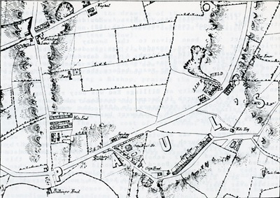
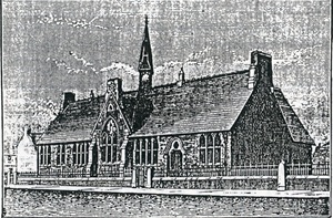
Figure 2. St. Silas' day school
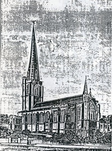
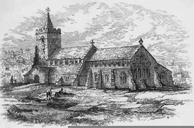
Fig 1. Blackburn Parish Church, Revd. S. J. Allen, 1819
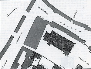
Fig. 2 Parish Church, 1819 (reduced from original).
By Mary Whalley
This article is an edited version of the history of St. Silas church which Mary Whalley compiled to mark the occasion of its 90th anniversary in 1990.
Although the Church of St. Silas was consecrated in the year of 1900 its roots go far back into the nineteenth century, roots firmly fixed in the small building near to the entrance gates.
The religious life of the little community at Billinge End and Mile End did not begin with the building of a church; it was flourishing well before that time. Therefore, a history of St. Silas' Church would not be complete without the story of the preceding seventy years.
In 1830 Billinge End and Mile End formed an isolated hamlet over a mile outside the rapidly growing town of Blackburn. There was little but farmland between Blackburn and Preston, broken now by the new turnpike road, Preston New Road, built in 1826.
Here lived handloom weavers and farmworkers and here in 1831 Joseph Feilden of Witton Park offered a site for a Sunday School. His offer included some stone "from right of road to Woodfold" and £20 subscription. In 1832 the final choice of site was "opposite the cottages, near the Toll Bar at Billinge End." By March 1833 land had been conveyed to the Trustees, rent free.
Rev. J. W. Whittaker, Vicar of Blackburn, in 1833 obtained a grant of £50 from the National Society in London towards a new Sunday School.
In 1834 the foundation stone was laid and Billinge End Sunday School was built, stone-flagged and with a gallery in the back room. There was a capacity for 150 boys and 150 girls and the final cost was £350 and £40 for furnishings. Rev. J. W. Whittaker performed the opening ceremony on April 19th, 1835.
The school superseded a Sunday School which had been held in the upper room of an old cottage in Dandy (Dinkley) Square, Mile End Row since 1833. The cottage was a small beginning but its influence reached out far beyond the hamlet at Mile End.
Billinge End School, as a Sunday School, belonged to St. Paul's Church, Blackburn. As it was not licensed for services, the people who lived in this area walked to the Mother Church of St. Paul's for divine services, weddings, baptisms and funerals.
From town (Blakey Moor) the boundaries of St. Paul's parish extended to Mellor in one direction and to Feniscowles in the other.
Figure 1. Plan of Blackburn Borough, 1852 (reduced)
Sunday School attendances in 1839 averaged 98 boys and 106 girls from a very small population, a population which increased to 2000 between 1840 and 1850. These early Sunday Schools were the first to recognise the need to educate the poor so instruction was given in reading and writing.
On January 1st, 1846, the Bishop of Chester licensed the clergy of St. Paul's Church, Rev A. G Edouart being Vicar, to conduct services and administer the Sacraments in Billinge Sunday School, "being desirous of affording all the relief in our power to the spiritual destitution of that district."
A grant of £80 per annum was obtained from the Additional Curates Society for a curate-in-charge and Rev. Edward Parker was appointed in 1846.
As the school was primarily a Sunday School there are no records between 1847 and 1874. When Rev. Wilson Stones became curate in charge in 1874, Sunday School records were begun, dating from May 3rd, 1874. One entry reads: - "On December 20th 1874 the weather was very winterly but there was no decrease in numbers, being proof that many, if not all, of the scholars did love their school."
In 1875 thirty pupils from the Sunday School were confirmed at St. John's Church. Soon an Infants class was required and the building was extended.
School attendance was made compulsory following the Education Act of 1870 and Billinge Sunday School became also a Day School in 1881. The first headmistress was Miss A. Moulding and the first entry in the log-book reads February 4th 1881.
Much support had been given to the Sunday School and its services, but as the area expanded it was now decided that there was a great need to build a church. A deed dated March 1st, 1879, states that a plot of land was given by Randle Joseph Feilden of Witton Park. But it was many years before the ambitious project became a reality.
Even though the community at Billinge End was busy raising funds to build its new church it became increasingly obvious that a larger day school was necessary. In 1885 the new curate-in-charge, Rev. M. Shaw, with a stalwart band of supporters, set about this other huge task.
A Building Committee was appointed; the Board of Education was notified that a Church School was to be built, financed by voluntary subscriptions and that the school would accommodate seven hundred and fifty scholars. There was fear in this dedicated community that a Board School would be built for them, which they did not want, so plans for a Voluntary School were hastened. St. Silas people wished to keep as much control as possible over their own school.
By an Indenture dated December 15th, 1884, made between T. A. Aspden and the Billinge School Trustees it was agreed that a day school would be built on a plot of land supplied by Mr. Aspden (timber merchant). This land would be bounded by new streets intended to be named Clematis Street, New Bank Road and St. Silas' Road. Yearly rent charges were later agreed for the land. Mr. Bentley of Kendal was the architect and Messrs. Kenyon and Moulding the contractors.
Figure 2. St. Silas' day school
After the school was finished in 1885 Billinge Sunday School was temporarily closed and the children removed to the new premises in August 1885. Mr. Mark Russel was appointed Headmaster. The new school was soon over-crowded and the Billinge school re-opened in 1886 as the Infants department.
Church services were held in the new school on Sundays and events both religious and social took place on week-day evenings.
In the church magazine of 1891 the school is entitled - "St. Silas Mission School, New Bank Road" and then referred to as the School-Church. Rev. Shaw announced, "This School-Church is free and open all who attend the services may be sure of a welcome." St. Silas Church magazines were begun long before the church appeared, originally the drawing of the single storey day school, seen above, was shown on the front cover. From January 1896 the illustration on the front cover depicted the design for the church with a spire (see below).
St. Silas' School was originally a one storey building but in 1895 it was seen to be too small. A Day School Enlargement Fund was set up. On October 24th 1896 a new wing to the school was opened by Mrs. W. Harrison. Bishop Cramer-Roberts, Vicar of Blackburn before becoming a Bishop, praised the light and airy voluntary school.
Still more space was required and in 1904 a second storey was added. By 1905 Sunday School scholars had reached an amazing 900 on roll and the Vicar, Rev. E. J. Bardsley, cried out for more voluntary teachers. The total cost of the school from 1885 to 1904 was £7000.
During these years the Billinge End School was in full use for various activities. In 1904 its name was changed to the Parish Room.
A large congregation assembled on May 15th 1898 in the Clematis Street School to hear the last sermon by Rev. M. Shaw and "to bid adieu to this humble House of Prayer previous to entering the more commodious and handsome Church." The School-Church had played a most important role over the last twelve years.
At a meeting of foremost members of the congregation held in Billinge School on May 2nd, 1894 a Building Committee was appointed to carry into effect the long delayed project of a new church. Rev. B. Thompson, Vicar of St. Paul's parish was chairman supported by Rev. M. Shaw.
The site of the church was already secured; 3630 square yards of land, given by R. J. Feilden, situated in St. Paul's parish on the north-east side of Preston New Road.
Messre. Austin and Paley of Lancaster were appointed architects in May 1894 and the plans prepared by them in October 1878 were accepted. These dates indicate the long delay between making plans and building.
Figure 3. Proposed church
The foundation stone was laid on December 8th, 1894, by Mrs. W. Tattersal of Quarry Bank. Mr. W. Tattersall had headed the subscription list with £1000. Already almost £3000 had been promised and later Mr. Tattersall gave a further £750. The silver trowel and ivory mallet used were presented to Mrs. Tattersall. Medal souvenirs at one penny and twopence each and a few silver ones were sold.
Time went on with tremendous enthusiasm shown and much fund-raising of smaller amounts of money to add to the larger donations of the wealthy. However, it soon became evident that it might not be possible to complete the building of the tower, as planned, immediately.
The contractors for the new building were Messrs. B. Graham and Sons, Huddersfield; joiners were Messrs. Dent and Marshall, Blackburn; some interior stonework including the pulpit Messrs. Bridgeman, Lichfield; and wood-carving Mr. Mills, Manchester. Mr. M. Whewell (a member of the Building Committee) was appointed Clerk of Works.
For the exterior walls local stone from quarries such as Revidge, Butler Delph, Grimshaw Park and others were used. Fine Yorkshire stone was used for the external dressings and pink flecked Runcorn stone gave a warm appearance to the interior walls.
In size the church was to be about 160 feet long, the body of the church 64 feet wide and at the chancel end 84 feet wide. The church spire was expected to be 208 feet high. The spacious interior was completed with north and south aisles divided from the nave by arcades of five bays each; a large chancel and Sanctuary; an organ transept and vestries. Lofty arches soared upwards. Electric lighting was installed and heating was obtained through a system of hot-water pipes. The estimated cost of the building was £9,584.
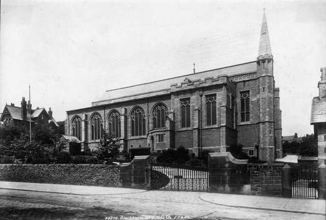
Figure 4. St. Silas' Church, circa 1905
In the document - "Sentence of Consecration" dated July 18th, 1900, it states that the new church contains 620 sittings of which 259 are to be free forever. All sittings for rent had been spoken for months before the church opened. Mr. W. Tattersall had made a special gift of £750 for the seats including cushions. He also donated the church bell.
The wardens' pews and the choir stalls were made from carved oak and the pews for the congregation were of French pine.
As the work neared completion the church grounds were laid out in April 1898 and shrubs requested for the newly made terraces.
By May 1898 all articles required to furnish the interior had been promised. The generosity of a warm and caring community was shown over and over again.
The Bishop of Manchester had dedicated the church and granted a Licence, dated 1898, for performance of Divine Services but there could not be the same opening ceremony as if the church had been consecrated.
Ascension Day, May 19th, 1898, was a happy occasion. The Church was full as the first sermon was preached by the Vicar of St. Paul's, Rev. B. Thompson.
For these important events a surpliced choir, including a few ladies, had been trained by Mr. M. Russel, the headmaster. The trustees were opposed to an elaborate musical service and hoped services would be "plain, hearty and congregational in character."
Baptisms could take place but marriages could not be solemnised until the Church was consecrated and a parish formed. St. Silas' Church was still in the parish of St. Paul.
The magazine of May 1898 indicates that the Church would be consecrated and a separate parish formed when the debt of £2,000 still burdening the church was removed.
In January 1900 in an effort to erase this debt and one of £800 on the day school, a huge bazaar was held in the Exchange Hall opposite the Town Hall. This bazaar, lasting five days, was the culmination of sixteen months work. The profit of £2,150 was used to pay off the school debt and the rest allocated to the Church.
St. Silas' Church was consecrated on July 18th, 1900, by the Lord Bishop of Manchester, the Right Rev. J. Moorhouse. The church was said to be "finished and adorned and furnished" and all Church services could now take place.
The Blackburn Times of July 21st, 1900, states, "There was a large and fashionable congregation and the clergy of Blackburn attended in large numbers." The Lord Bishop conducted a communion service and after his sermon signed the Sentence of Consecration.
On August 3rd, 1900, Rev. E. J. Bardsley was nominated as minister. He had commenced duties as Vicar-elect in April. Land to form the parish of St. Silas was taken from the parish of St. Mark in December 1900. This whole area had formerly belonged to the parish of St. Paul.
Numerous gifts were accepted with gratitude in the early years. Amongst these were promises of the pulpit, the font, the organ, the communion table and linen, communion plate, alms dishes, communion chairs, Bibles and prayer books, choir surplices, umbrella stands and carpet.
Hymn books for the use of strangers were supplied but regular worshippers had to provide their own. From Yealand Parish Church came gifts of a reading desk, communion cloth and kneeler. The clergy and choir vestries were also furnished through gifts.
Beautiful stained-glass windows adorn the church. The magnificent East-end window, unveiled in 1905, was the gift of Mr. J. E Fielding at a cost of £800. The window is in memory of the time when he and his wife taught in the old Billinge Sunday School.
Parishioners were busy with events which were not dull. One lady remarked in 1906, "We are in the midst of a most uproarious time, socials to the right of us, socials to the left of us and socials in front of us,” all with the aim of raising money. "We cannot be said to take our Christian life sadly."
Now the completion of the church was contemplated. The scheme for a spire was abandoned as too costly. In 1911 Rev. Bardsley left. He was given "a splendid send-off, showing the affectionate regard in which he was held." Rev. H. J. Smith was inducted in 1912 and led the work of building the tower.
St. Silas Church was completed by the addition of a handsome tower, 104 feet high. An enthusiast wrote in 1914, "It is a poem in stone and a landmark for miles around". The North and South aisles had been extended and the new porch and doorway made a fine entrance. In a niche over the porch is a carved figure of St. Silas.
The work was carried out by Messrs. E. Lewis and Sons, Blackburn and cost over £6,000. The foundation stone of the tower was laid on Ascension Day, 1913 and the Consecration took place on Ascension Day, 1914.
The beautiful alabaster reredos in the Sanctuary was transported from Italy in 1915. It was presented by Mrs. Henry Harrison in memory of her late husband who died in 1914.
War took its toll! A "Roll of Honour" compiled by Mr. T. Jennings as a war service record for the parish states that, up to November 11th, 1918, of 600 who served 96, including Nursing Sister Robins, died. Many honours were conferred. Of three Blackburn V.C's won in this war two were gained by St. Silas men.
In April 1918 Second-Lieutenant John Schofield was killed in France and was awarded the Victoria Cross for conspicuous bravery. A regular communicant he attended both St. Silas' and St. Thomas' s Churches.
Also, in August 1818 Lieutenant-Commander Percy Thompson Dean, R.N.V.R was awarded the V.C for heroism at Zeebrugge. After his death in 1939 a special Memorial Service was held in church of "one of Blackburn's most distinguished sons."
Captain Leonard Heatley, a former solo chorister, was killed in Belgium in 1917. A richly carved and decorated Memorial screen, erected behind the Wardens' pews, was presented by his father, Mr. T. H. Heatley and dedicated by Rev. H. J. Smith on September 12th, 1918.
As life became peaceful Church organisations flourished again. These included the Band of Hope, the Church Missionary Society, Bible Classes and Evening Classes which were begun before 1892. Some years later a long list includes: - Church Lads' Brigade, Gleaners' Union, Scripture Union, Girls' Friendly Society and a Servant Girls' Guild. The Mothers' Union came into being in 1913. Social activities, such as the Lyric Society, were encouraged for the well-being of the parishioners.
Field days were held on the Yellow Hills where the cricket and football clubs had their pavilion. Annual processions of seven hundred people marched there with Mellor Brass Band leading the way. In 1920 the Girl Guides, Brownies and Boy Scout companies were formed. Many years later other groups including the Ladies Fellowship, Young Wives, Bellringers and Men's Fellowship have arisen.
In 1920 "Royle" on Gorse Road was bought as the first Vicarage. Previously houses had been rented. In 1940 "Royle" was sold to St. Mark's parish and "Fair Elms", a Victorian house, in close proximity to the church was bought. This was demolished in 1960 and a modern Vicarage was built on the site.
Those early Curates-in-Charge and the organist who bought his coals to warm his choir boys would have marvelled at all that had arisen from their earnest "spadework" on that plot of land "opposite the cottages near the Toll Bar at Billinge End".
In July 2025 St. Silas's Church celebrated the 125th anniversary of its Consecration.
A number of concerts were planed in celebration of the event.
Acknowledgements
With grateful thanks to the Church Authorities for generous access to their documents, deeds and church magazines. Similar thanks are also due to the staff of Blackburn Reference Library and Lancashire Record Office.
Figure 1 is reproduced by kind permission of Blackburn Library. Figures 2 and 3 are from the Church Magazine, and figure 4 is reproduced, by permission, from the Revidge Collection.
Article published in The Blackburn Local History Society Journal 1990. Pages 30-37.
Transcribed by Shazia Kasim.
Published Octobe 2025
By Maggie Simms
In Blackburn, it is a well-known fact that the pre-Conquest parish church stood to the north-west of the present cathedral on an area now landscaped with lawns, flower beds and trees.
For a number of years, the Museum has alternatively watched over work on the site and made small excavations (Davison 1978, Edwards 1985). Some artifacts exist to throw a little light on the appearance of the old church and its treasures. Fragments of painted glass are incorporated into one window of the present cathedral; and the cathedral possesses a golden 'pax' recovered from the graveyard in the nineteenth century.
In 1987 funding for a six-week project was obtained with support from the Community Programme.
Aims and Objectives
The aim of the project had originally been to continue a small excavation adjacent to trial trenches made in 1985. These had shown that the tower and north-west portion of the church were badly eroded. Further excavation was intended to reveal more of the wall-blur of the tower, and to locate the Walmesley mortuary chapel, known to be in the tower area.
However, this aim had to be abandoned in the light of objections made by the Borough's tree specialist. A mature elm had blown over in 1986, possibly after some root disturbance following the 1985 excavation. Several other mature trees on the site were subject to a preservation order; moreover, the entire site had been planted with saplings of many species to create an arboretum. This latter move was clearly incompatible with the safety of the archaeological site.
As a conciliatory move, and to get the job done, the aim of the project was therefore shifted. A large-scale geophysical survey of the site would be attempted instead, in order to locate the whole church and any related features. It was intended initially to include a small-scale excavation to clarify details at the north-west end, but events proved this to be inadvisable.
The end product on the site was to be a plan of the church marked out on the surface, with a public information sign to explain its significance. With some minor setbacks, this was achieved.
Background: Literary Evidence
The earliest literary reference to the site is by John Lyndelay, a 14th century Abbot of Whalley Abbey. In his "De Statu Blagborneshire" he stated that several 6th century churches were founded locally as an off shoot of the Augustinian mission to England. These churches were at Blackburn, Chipping and Ribchester.
This statement is not supported by any other literary evidence, and indeed the likelihood is that Augustine's mission was not effective in North-West England. This does not mean that Christian sites did not exist here at this early date, merely that they remain to be proven.
The entry in the Doomsday Book (1086) for Blackburn runs as follows:
King Edward held Blacheburne. There are two hides and two carucates of land. The church had two bovates of this land and the church of St. Mary had in Whalley two carucates, free of all customs. In the same manor woodland one league long and the same broad, and there was a hawk's eyrie. To this manor or Hundred were attached twenty-eight freemen who held five and a half hides and forty carucates of land as twenty-eight manors. A wood six leagues long and four broad, and (the manors were subject to) the aforesaid customs.
From this we can conclude that a small but thriving economy existed in the area. We know nothing about this church's appearance. Durham's evocative description of the entrance (1) is probably conjectural.
There are however other literary sources that give some indication of the church's appearance. It was rebuilt in the fourteenth century in the current architectural style, which we term decorated Gothic (2). It was altered again in the sixteenth century when the building appears to have been re-roofed to provide the shape seen in the Allen drawing of 1819 (fig 1).
Fig 1. Blackburn Parish Church, Revd. S. J. Allen, 1819
By this time several locally important families had endowed chapels and windows. These included the Petre, Dunkenhalgh, Osbaldeston, Walmesley and Derby families. The latter family founded the Lady Chapel on the south-west corner of the building in 1509. Abram provides a detailed description of the building at this date (3), but this seems to be based on the Allen drawing.
Rev. Allen's drawing provides the first and only reliable picture of the old church above ground level and was clearly used as source by later local historians (4). It was drawn in 1819 after the decision to demolish the church had been made. A map (fig.2) in the Chapter Surveyor's archives shows the old church in plan form, the adjacent properties and the proposed churchyard extension of 1819, which included the rerouting of the River Blakewater. The plan on the 1819 map and the Allen drawing show a marked similarity and should be treated as reliable.
Fig. 2 Parish Church, 1819 (reduced from original).
The decision to apply for an Act of Parliament to rebuild the dilapidated church was made at a Vestry meeting, chaired by the Rev. Thomas Starkie, in August 1818. The intention being to rebuild the body of the church while retaining the old tower. It was during the vicariate of his successor, the historian and antiquarian Rev. T. D. Whitaker, that the Act was passed and the decision taken to relocate the church.
It would be harsh to judge this decision hastily from our modern stance. We should remember the phenomenal growth of Blackburn in the early nineteenth century. The small cemetery surrounding the parish church was still the main burial ground for the town centre parish.
The situation could not be eased by extending the existing building as the land was covered in burials. Moreover, the grammar school was situated within the grounds of the parish church. By relocating the school and building the new church on this released plot of land, in the centre of enlarged churchyard, the Vestry of Blackburn at least allowed the old church's remains to survive to posterity.
Not all of the church was demolished in 1819-20. A portion, probably part of the choir and chancel, was left standing until the new church could be used (5). This was demolished before the consecration of the new church in 1827.
The tower of the old church was left standing until 1870. One photograph exists of it showing a rather squat structure, with buttresses at each angle, and a blocked archway converted into a window. This is quite different to the tower shown in the Allen engraving, with pointed-arch windows, an embattled roof, gargoyles and a small, recessed spire. The difference is accounted for by building work done in 1833, when apparently the tower was lowered. An outcry prevented the total demolition of the tower in 1857 (6), and it survived until 1870.
Subsequent to the demolition of the nave, the area of the old church was packed with earth and re-used for burials. When the tower was demolished a second curving path was built across the site. This path can be seen on serial photographs, and on numerous maps.
As late as the 1950s the remaining grave slabs were removed leaving four large free-standing tombs, and the site was landscaped. Trees have grown to maturity on the site, and the path system has been altered.
Evidence from Maps
Apart from the map of 1819 and the first edition of the Ordnance Survey of 1848, no other maps show reliable details of the old church. Maps exist in Blackburn Library from 1736, 1795, 1822, 1824 and frequently throughout the nineteenth and twentieth centuries. These maps are extremely useful for indicating the existence of the settlement core in the Darwen Street/Church Street zone. Particularly useful is the present 25-inch O.S. map, where spot heights indicate that the settlement occupied a ridge running roughly north-south close to the River Blakewater.
The 1848 O.S. map is particularly useful as it marks the tower of the old church. It proved to be one of our key clues to the present position of the old church.
Locating the Church: The Geophysical Survey
Resistivity surveys have become more widely used by archaeologists because, unlike the traditional 'dig', they are non-destructive of the site. The ground basically conducts an electric current with a measured amount of resistance. The presence of buried masonry, for example, will change the current measurements and produce a different reading to that of the surrounding soil. The survey involves taking a large number of readings on a grid pattern, the results of which are then analysed by computer.
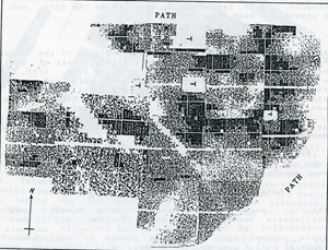
Lancaster University's Department of Environmental Science loaned a Geoscan R4 resistivity meter, and this was used to cover the entire site at 0.5 metre intervals. When processed, the 16,000 plus readings indicated a number of findings: -
1. There are substantial stony remains at the east end of the site. A contour map and the dot density map (fig. 3) indicate the five buttresses shown on the 1819 map and the Allen engraving. Moreover, the width of the structure at this point as indicated by the survey is some 20 metres, varying only slightly from the width shown on the 1819 map (65 feet).
2. A path built relatively recently has removed all but about 6 metres of the north wall of the church, destroying it and any associated evidence.
3. The centre of the church site shows deep disturbance, which aligns with a path and associated lampposts. This path existed from Victorian times until recently.
4. The west end of the church lies in a very disturbed zone and no indication remains of the tower's wall lines.
5. Another square-ended structure aligned north west-south east, can be seen on the north side of the site bordering the path. This may part of an earlier feature.
6. There are numerous 'holes' in the site where trees are growing.
Fig. 3 Dot Density Map (T = standing tomb)
Locating the Church : Mapwork
As the above shows, geophysical data could not be used to locate all of the old church on the ground. Moreover, property boundaries and street lines have altered significantly in this zone, so they are no longer reliable fixed points.
As an illustration, the adjacent Waterloo Buildings have a back wall of large sandstone blocks which looks as though it could have been aligned to the old church. Research showed however that despite its name, this range of buildings was not erected until 1835, well after Waterloo. A painting in Blackburn Museum of the general election of 1832 shows a quite different range of buildings on the street in question. Therefore, the Waterloo Buildings replaced an earlier range of buildings and swept away their property boundaries, being planned as a whole new block of nine units and aligned to Church Street.
The 1840 O.S map, however, marked the new gateposts built for the new parish church at the corner of Church Street and Darwen Street. These gateposts and their ornate iron fittings still stand. They are octagonal in section and are about 3 metres high. They will have deep foundations and I doubt if they have been moved since their erection.
Using these gateposts as fixed points we were able to peg out the position of the tower on the ground. The remainder of the old church was pegged out using the 1819 map as guidance. It was gratifying to note that all the tombs on the lawn fell within the wall lines as we plotted them, confirming verbal evidence.
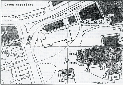
Fig. 4 Cathedral Area, 1987 with church site added
The Present Ground-plan
Visitors to the site can now see the outline of the old church marked out in a foliage plant, appropriately known as 'yellow archangel'. The ground plan is shown in figure 4. A plaque has been erected to describe the site.
Conclusions
The site of the ancient parish church of Blackburn survives intact in some parts despite considerable erosion in others.
It has escaped redevelopment uniquely in this town centre zone, and its present condition is remarkably good considering that no legislation has protected it to date. It is ironic that a preservation order covers the trees which are currently destroying it.
The Borough should seek to have this site scheduled as an ancient monument so that its continued existence and safety are assured.
References
(1) W. Durham, Chronological Notes, (1866), p. 8.
(2) G. C. Miller, Byegone Blackburn, (1949), p. 55ff.
(3) W. A. Abram, A History of Blackburn, (1877), p. 302.
(4) See Abram, Durham, Watson.
(5) W. H. Burnett, A History of Blackburn Parish Church, (1905), p. 44.
(6) G. C. Miller, op. cit., p. 58.
Acknowledgements
The following people are thanked for their kind assistance:
The Cathedral and Chapter Staff, Blackburn Cathedral
Blackburn Borough Surveyor's Department
Peter Iles, C.L.A.U
Brian Robinson, Lancaster University
Blackburn Reference Library and Staff
Blackburn Museum and Staff (and for permission to use fig. 1)
Peter Jepson
C. J. Ward
Article published in The Blackburn Local History Society Journal, 1990. Pages 4-10.
Transcribed by Shazia Kasim
Published November 2025