Historical Development of Whitebirk and Intack Areas
By
Mike Sumner
SITUATION
Whitebirk and Intack areas form a suburb to the east of Blackburn centre. Part of the area now falls within the Borough of Blackburn with Darwen whilst the eastern section falls within the Borough of Hyndburn. To the north-east of the area is the town of Rishton with the Greenbank and Little Harwood areas of Blackburn to the west, Sunny Bower area to the north and Accrington Road to the east. The main line railway from Accrington to Blackburn runs along the northern border from west to east and the Leeds Liverpool Canal crosses the area from south-west to the north. On the eastern edge of the area is the M65 Motorway which has four slip roads leading on and off it via Whitebirk roundabout.
EARLY HISTORY
The word Whitebirk has Saxon roots derived from Hwite-Byre meaning white or silver Birch trees. Originally, the area was forested, being part of the woodland that stretched from the Ramsgreave, Mellor ridge slopes to Little Harwood, and, in the early days, was used by Lords and Royals for hunting wild boar, deer and other animals and birds. The wood was also used to construct early housing and provide charcoal for smelting metals. The Anglo-Saxons were in the north-west of England from the sixth century to the Norman invasion in the 11th century and the Medieval Ages. Nearby Rishton’s name was derived from the word Rise, Rush and Tun meaning a place of rushes, which was accurate as its area was partly recovered bogland from Rishton Moor. Intack originally named Intake was first mentioned in the late 1700’s, early 1800’s and could possibly relate to an area of farmland that had been enclosed after being former common land. At the same time, Tooka from the word Takka relates to ewe in the 16th century and Takely relates to a pasture of Tegs (sheep). It is likely that the two areas of land would have been owned by either the Lords of Blackburn or Rishton, and later, by Norman knights, after their successful invasion in 1066. Lancashire, however, was amongst the last English territories to feel the effect of the Normans and Lord Gilbert de Lacy was first to seize land in East Lancashire. Another knight who took lands in the area was Lord Roger de Poictou and both knights were under the service of William the Conqueror. The local lands used by farmers would have been rented out from the lords who would provide them with protection. The Doomsday Book stated that Edward the Confessor held 'Blagborne' which had a wood one mile long and wide which was home for hawks. He also held Huncoat with a wood six miles long and four miles wide, and therefore, held the Whitebirk and Intack areas. In the 12th and 13th centuries Rishton, Whitebirk and Intack areas were controlled by the De Rishtons, Gilbert de Lacy, John de Ratcliffe, Adam de Billington with the De Lacy’s dominating the main central areas of Blackburn. Edward IV gave Blackburn lands to the Talbots of Bashall. In Tudor times a variety of Lords controlled Rishton areas including Nicholas Ryshton, Nicholas Feilden, George Livesey, George Abbot, Xpofer Whalley and William Hogeson.
The most important early road or track through the area went from Preston to Blackburn via Preston Old Road then, via Whitebirk, on to Rishton and then Burnley, providing vital access to Whitebirk and Intack areas. From 1618, the enclosure of common and waste land occurred which would have affected owners of farmland often cleared from woodland in the Middle Ages. Owners of land at Whitebirk in the 1600’s included George Abbott in 1622, who was from a family of ancient freeholders and lesser gentry and John Abbott from the same family in 1636 who was also elected as a Governor of Queen Elizabeth’s Grammar School in 1646. There was also a James Abbott of Higher Whytebirk Farm who died in 1659. At this time, Lord Fauconberg was the Lord of Blackburn Manor and held lands at Whytebirk. During the 17th century the Civil War occurred. The Earl of Derby held the Blackburn area for the Royalists but was then overthrown by Oliver Cromwell before the Monarchy and Charles II regained it in the 1660’s. By now, lands in Rishton and probably Whitebirk were owned by Thomas Whalley, Thomas Talbot, Christopher Hindle, William Bell, Christopher Duckworth, Robert Dewhurst and John Baron.
During the 17th century local rural economies included handloom weavers as part of the Domestic Textile Industry based around Blackburn living in small communities and hamlets up to six miles from Blackburn, including the Whitebirk and Intack areas. Each weaver working from their cottage signed up with a Blackburn cotton merchant e.g. Robert Hopwood or George Briggs who had up to 8oo handloom weavers on their books as part of a “Putters Out“ system. This involved them with supplying the weavers with spun cotton, if they didn't spin their own, in which case they would supply raw cotton and then collect the woven pieces from them at set prices depending on their size. The weavers produced cloths that could be used for jaconets, checks and shirting material. Up to 1800, it was estimated there were 20,000 handloom weavers within three miles of Blackburn centre with completed cloth pieces mostly sent to London, or, printed locally. Also, it is known that early bleaching of cloth was carried out at the same time in the Whitebirk area, where cloth was spread out in fields for the sun to bleach it. Richard Bently was working bleaching grounds in Whitebirk in 1793. By 1779 handloom weaving shops were created, handlooms would be collected together in farm buildings such as barns creating an earlier form of the Factory Textile System. It is also noted that there was an old stone detached cottage built at Whitebirk which had a hoist beam and a “Taking In" door on the gable end for taking in cotton probably. The cottage had a date stone for 1770 indicating it was built by Edward and Elizabeth Brewer whose family had interests in the early textile industry of Oswaldtwistle. By the 1770's pieces of cloth created for India were called Calicos.
Yates map of 1786 shows a Turnpike Road following an earlier route already described above, which ran from Preston to Blackburn and on through Whitebirk to Burnley. These had Toll Houses along the routes, a fee paid for using them which provided funds for maintenance of the road; they were operated by Trusts. This road can be seen below on the 1786 map running from Houghton in the west passing through Blackburn and on to Bottom gate, Hole House, Whitebirk and on to Rishton.
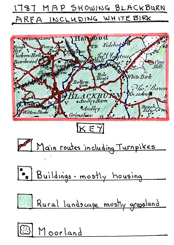
A 1787 Map showing the Blackburn Area including Whitebirk.The 1787 map shows the turnpike road mentioned above running from Witton Stocks through Blackburn, Bottom Gate, Hole House and White Birk. At White Birk one of the larger black squares denoting a building on the junction of two roads would be one of the oldest inns in the Blackburn area first built in 1735, namely, the “Red Lion”. It is unique for an inn in Blackburn as it was classified as an Ancient Monument which meant it couldn’t be altered greatly. It has well preserved features including mullioned windows and a steeply pitched roof typical of the 1700’s with stone slates. All its original beams and woodwork had no nails in them but were held together by hand-made pegs and dowels.
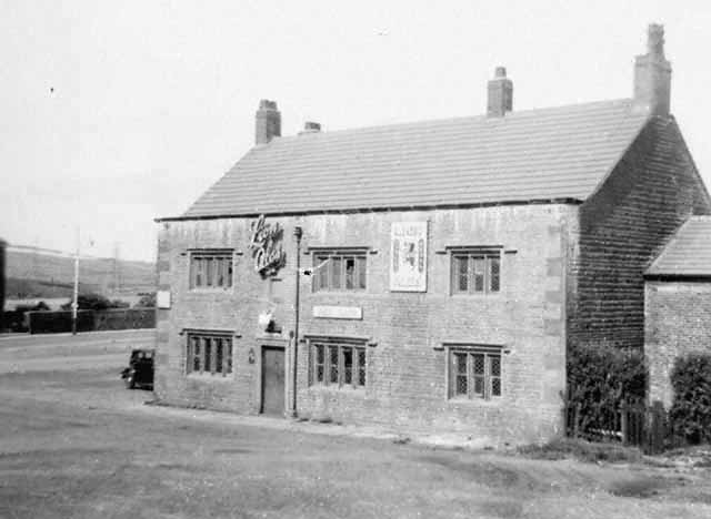
A picture of the Red Lion Inn in 1953 owned by Lion Brewery but first built in 1735The inn was ideally situated to serve both the locals of Whitebirk and Intack and travellers passing along the ancient toll road shown earlier on the 1786 map. During the 1700's much of the rural land in the Whitebirk and Intack areas had been cleared of woodland but was often barren including the nearby Rishton bog land and the soil was of a poor quality. The soil needed to be upgraded, and, as farm machinery developed during the Agricultural Revolution, farmers could do more on the land. Farms were mostly pastoral with sheep and cattle raised, oats was the main crop grown both for a fodder crop and used by locals to produce porridge a staple diet during this period for poorer people.
At the start of the 1800's, the golden age of “hand looms" had passed because of the early development of the Factory System, first with banks of hand looms in workshops, then later, with steam power looms in the new factories that were built which badly affected the independent hand loom weavers' business and brought down the price of cloth. As a result, many of the hand loom weavers migrated from rural areas such as Whitebirk and Intack to obtain work in the newly established cotton mills. The number of mills grew enormously in the Blackburn, Accrington and Rishton areas and this was referred to as “Rural to Urban Migration". The remaining hand loom weavers were forced to produce fancy goods the power looms could not. The life of the hand loom weavers was hard, reliant on putters out who hadn't moved into operating the new cotton mills. Their staple diet was oatmeal porridge with churned or sweet milk, potatoes made into stews with onions added but rarely with meat. Many of these remaining hand loom weavers became destitute with large families having to cope in small cottages as they sought new work on nearby farms, but, by now, farm machinery meant fewer workers were needed other than at harvest time. In earlier periods there was a chance of work when early textile developers did not want to finance a new mill so developed sheds for 30-40 hand looms including some farmers using their barns or outbuildings.
By 1818, the Leeds Liverpool canal was completed and passed through Whitebirk on its way to Blackburn centre coming from the Burnley and Rishton areas. The canal offered cheap reliable transport especially for heavy goods and attracted early industry especially textiles to its banks for easy access to barge traffic and a water supply for steam power. By the 1820’s there was a regular passenger service from Blackburn to Burnley through Whitebirk. The passenger barges had roofs and side windows with extra passengers sitting on the roof.
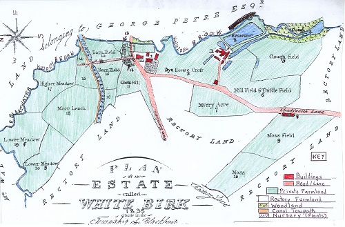
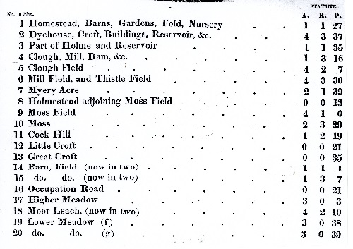
A Map/Plan of The Whitebirk Estate in 1835 With Key
The above map/plan shows Whitebirk as a scattered hamlet in 1835 which, at its centre, had the Red Lion Inn to the left of No. 1, where Burnley Road, coming from Blackburn, continues into what is now Blackburn Road running to Rishton. At this time, Shadsworth Lane would have run through Intack (off the plan) on to Shadsworth but is later called Whitebirk Road. The newly built Leeds Liverpool Canal in the estate is shown with its tow path on which the horses pulled the barges. Using the key (No 16), Occupation Road just crosses the canal and ends but does not continue to Brownhill and follows the line of the later larger Whitebirk Drive. As can be seen, lands to the south and west belong to the Rectory (Church land from St. Mary’s Church, later Blackburn Cathedral in Blackburn centre). To the north and east is part of the Petre family estate who controlled much of the Rishton area and farmers of these areas would lease land from them. As to the settlement at (No1) Whitebirk hamlet there is a cluster of homestead buildings including barns which could indicate a farm indicated by (No5) but clearly a diversified one as it has gardens and a large nursery to supply plants or shrubs to locals or nearby Blackburn areas. The building at No 2 was one of Blackburn’s oldest industrial sites developed from the original outdoor bleaching activity into industrial buildings for chemical bleaching and dyeing developed probably by Richard Bentley, but, owned at this time, by Robert Peel of Accrington, who leased out the premises. Part of the property used for dyeing was leased by T. H. Maude a calico manufacturer and dyer during the 1830’s. Machinery used in the buildings included a steam engine and water wheel, using water taken from the nearby Knuzden Brook via a goit and from Rishton reservoir to feed the works own reservoir. In 1835, Haworth and Barnes chemical manufacturers of Church leased the buildings, and, by 1839, James Barnes a calico bleacher of Accrington had taken over and the Barnes family continued a long association with these works. The original buildings were made of stone and mostly single storey with roof ventilation. At the entrance to the track leading to the works was a detached stone cottage built in 1770 and mentioned earlier in the 1700’s era. It is probable that the house was used as a receiving warehouse for yarn. The building adjoining Moss Field (No 9) numbered No 8 on the plan was called White Barn Doors shown on later maps and consisted of a series of cottages built by the side of Shadsworth Lane and involved in farming the nearby land and could possibly have been farm cottages from the two Whitebirk Farms off Blackburn Road leading to Rishton.
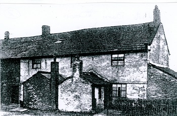
Early photo of White Barn Doors Cottages
The picture shows that the properties were brick built with clearly defined outhouses and were two-storey. Above Clough Field (No 5 on the plan) is part of the remnants of the original woodland that covered the area. As can be seen the fields on the plan are all now enclosed and owned with names attached which indicate that those in the east/south-east/south-west were of poorer quality including mention of moss, thistle and clough (cleared woodland). Those in the centre of the area are clearly older and smaller and of better quality as they have most likely been improved including Little and Great Croft (Nos 12 & 13) and Barn Fields (14 & 15). Samuel Heywood, writing in 1818, outlines the miserable situation of the rural districts in Blagbornshire having a thinly scattered population who were uncivilized and ungovernable as a result the bishop abstained from having jurisdiction over it!
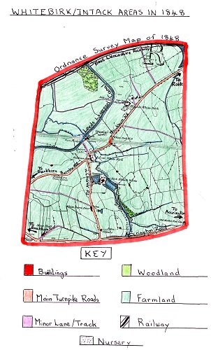
The 1848 Ordnance Survey Map of Whitebirk and Intack AreasThis map clearly shows a more complete and larger area of Whitebirk and Intack than the 1835 plan but with a smaller scale. The settlement is still scattered but sited mainly alongside main routes, namely Burnley Road to Blackburn, Blackburn Road to Rishton and Whitebirk Road (Shadsworth lane) to Intack and the main Accrington Road. At the centre, Homestead Farm now has more nurseries and cottages can be seen alongside Blackburn Road, with farm buildings, also at Higher Whitebirk Farm along with numerous outbuildings and cottages. The field pattern displayed indicates the better, flatter land near the centre of the area, the east and south had smaller and more numerous fields, those to the north and west are larger, where land was of lower quality, with slopes mostly used for grazing sheep with the smaller fields used for raising cattle and fodder crops. Intake (later Intack) is shown as a very isolated area south of White Barn Doors with two properties and a ruin with the area used for farming. On the Leeds Liverpool Canal can be located a wooden turn-bridge just north of Whitebirk centre allowing the minor track (later Whitebirk Drive) to cross the canal to get to land on the other side. As houses at this time often didn't have a direct water supply there were numerous local streams other than Knuzden Brook from which to obtain water supplies. By this date some steam powered machinery for farmland would have been used although horse drawn equipment would still dominate as it did for road transport. At this time, Charles Tiplady, writing in 1849, describes a walk along the banks of the River Blakewater that Knuzden Brook joined to the west of the Whitebirk area having in the past clear water you could drink from but now was heavily polluted due to industry developing alongside it e.g. Whitebirk Bleachworks. By 1848, Whitebirk Bleachworks was operated by Barnes Brothers & Co. and the business had expanded with more buildings and another large reservoir to store water to run its steam engines. This was due to the rise of the Textile Industry, with cotton mills springing up outside the area in nearby towns. Another business started in this period was Whitebirk Chemical Works which was opened in 1846 by James Pollard of Oswaldtwistle, however, by 1848, his partner, John Grimshaw became the sole owner. A bobbin turning shop and sawmill was later added to the site by the side of the Leeds Liverpool canal on former farmland and marked on the 1848 O.S. Map. The works produced dyes and oils in the early days but only from small premises. In 1851, the Borough of Blackburn was first established which led to it creating Borough boundaries with one passing through Whitebirk dividing it off from Hyndburn. Another major change in the Whitebirk came with the creation of the East Lancashire Railway which ran across the extreme north of the area. At its inception in 1845 it was called the Manchester, Bury and Rossendale Railway Company, however, it then amalgamated with the Blackburn and Preston Railway Company and became known as the East Lancashire Railway. This provided a new mode of transport for the area as it ran from Blackburn to Rishton and on to Burnley. In time, the railway took over much of the canal's transport trade as it was a faster than the barge. Moss Hall, in the extreme southern corner of the map, was close to Accrington Road. On the outer edge of the Intack area was an old farmstead which had mullioned windows indicating its age which dated to the 17th century. It was originally the home of the Whalley family of Sparth and Whalley and records show there was a William Whalley living there in 1692, and probably, his son James in 1713 and grandson Thomas in 1725. In 1744, a John Whalley lived at Moss Hall and was still there in 1768. Moss Hall then came into the possession of the Kenyon and the Nutter families. The end terraced houses at the Fountain Inn cross-roads on Accrington Road are called “Moss Hall Terrace" and were built in 1884. The last family to live at the Hall were the Wood family before it was demolished in 1930.
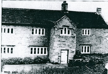
A picture of Moss Hall as a detached farmhouse with mullioned windows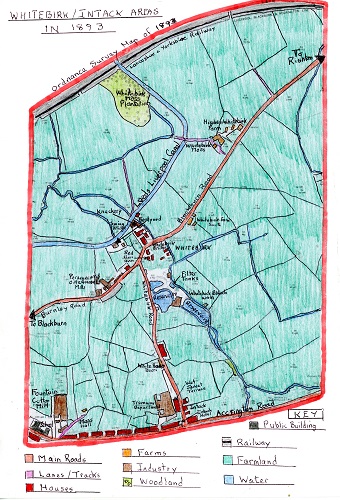
The 1893 OS Map of the Whitebirk and Intack Areas
The first thing that the map shows despite a lapse of 45 years, is that the area has not changed greatly and is still dominated by farmland. The map indicates that the field patterns have little changed but there has been an additional farm created, namely Whitebirk Farm South. By now, although farm machinery had become more mechanised, first by steam power, and, more recently, by fuel, horses would still be used on a large scale. The main building at Higher Whitebirk farm had grown larger, and, by now, the word Whitebirk is shown as one word rather than two. Housing in the area is still small and scattered apart from a large growth of Victorian terraced houses along Accrington Road as settlement in the Intack area increased, along with a name change from Intake. An interesting additional row of Victorian terraced had also been built alongside Whitebirk Road called Wet Jacket Terrace and the Intack Hotel had been built at the junction of Whitebirk Road and Accrington Road. At the same time, the map show Intack's first Primary School on Accrington Road.
By 1893, the largest change to the areas was the increase in industry. Whitebirk Bleachworks is shown having a larger building for bleaching and dyeing cloth and was still run by the Barnes Brothers. Whitebirk Chemical Works, sited by the canal, and formerly operated by John Grimshaw & Co. in 1874 to make dyes for the Textile Industry had not lasted long before Grimshaw and Parkinson took over forming a “ Turkey Red” Dyeworks. In time, that too failed, and the premises were bought by Joseph Davies, a horse slaughter. In 1881, he had a bone works in fields to the north of the area, where later, the electricity works were built. This is the site shown on the map as a 'Knackery'. The land owned by Davies where the Bone Works had been sited was now farmed by the family with horses, sheep and cattle. The family were one of the largest horse dealers in the whole area with local breweries and the Borough Corporation all buying from them while others were exported abroad. The Davies family didn’t just slaughter horses but cattle and other animals; a lot of the meat was sent to London. They also bought carcasses for the business from a radius of 50 miles. Certain parts of the carcasses were made into fertilizers with the fat sold to be made into soap and the hides sent to tanneries to be made into leather. The company used to move dead horses or other animals on a skeleton cart with the animal laid on its back, the head hanging over the front and the rear hanging over the back but later these were made redundant and they had to use closed trucks.
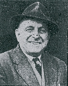
Mr. Joseph Davies, the founder of the company
The 1893 map also shows the Perseverance Oil and Grease Mill sited alongside Burnley Road. Originally, in the 1850's, it was a small naphtha and chemical works which was taken over, in 1868, by john Eccles, an oil refiner, who first started in business in 1808 before moving to Whitebirk. By now, the works refined lubricating oils and grease mainly for industrial use. The first mineral oil ever imported into the country was for the Eccles Whitebirk company. The site was altered between 1882-4 when Mr. Eccles also built a school for his workers children. His Oil Works were two storey and at the rear had a plaque on the wall advertising the company.
In 1872, the Darwen Mining Co. Ltd. sank a coal shaft into coal seams via the lower Mountain Mine (Whitebirk Colliery). It had two double steam winding engines to operate two cages going down the 408ft shaft and had 40 coke ovens built near the pit head, and had approximately 120 employees. The boundaries of the mine ran through nearby Furthergate, Shadsworth, Knuzden and Whitebirk itself. There were also coal pits on the area now covered by Philips Road which were 240ft deep called Armistead Colliery, and, where Whitebirk industrial estate is now sited was the Cross Head Pit which ceased work in 1888. The original company operating the Whitebirk Colliery failed and the pit was operated by the main creditors, namely, Darwen Co-operative Society and was now called Whitebirk Colliery Co. It was sold again, in 1890, to W. H. Shaw & Co. of Belthorn and Haslingden. The pit workings extended into a top coal seam of fire clay and coal which led to a glazed brickworks being added to the site to meet the need for bricks with terraced housing being built around the new textile mills. By 1896, the mine was completely abandoned but W.H. Shaw & Co continued the brick works and built an aerial wire flight from Belthorn to Knuzden in 1903 with 60 trucks to carry coal and clay before steam locomotives took the cargo the rest of the way to Whitebirk brick works. Whitebirk coal mine itself was sited to the side of Whitebirk Road with a two-storey office and stable by the road.
The mine site had a glazed brick chimney erected at the pithead which remained there till the 1930’s. Whitebirk colliery was one of the last operating on the Blackburn Coalfield where mining of various sorts could be traced back to 1569 when Bell Pits were first used to reach the higher coal seams.
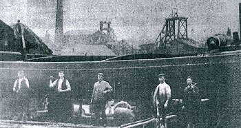
A picture taken from the nearby Leeds Liverpool Canal bank showing Whitebirk Colliery
in the background, in 1896, and Whitebirk Boat Yard in the foreground
In 1870, T & J Hodson established a boatyard on the banks of the Leeds Liverpool canal (see 1893 map) bringing boat building skills to the yard learned earlier in the Tarleton area. He bought the premises from John Grimshaw of Whitebirk Chemicals as it had a bobbing turning shop and sawmill on a 21- year lease from the Canal Co. James Hodson was joined later by his three sons. During the early days, they could build a barge for £180 when labour costs were much lower e.g. in 1878 it was 5 shillings and two pence per day. Originally, all the skills used to build a boat were done by hand including using large saws to cut the oak timber and seam caulking, which was packing the gaps between the boats flat bottom planks to ensure they were water-tight before tar was added and then the barges were launched down slips into the canal. By the end of the 19th century, the yard had three slipways, two for raising boats out of the water for repairs and one to launch boats back into the canal. By now, they had 12 workers to operate the yard. Their main customers were the Leeds Liverpool Canal Co., Rishton Colliery and Shackleton’s and Appleby’s grain carrying companies who obtained their grain from Birkenhead Docks.
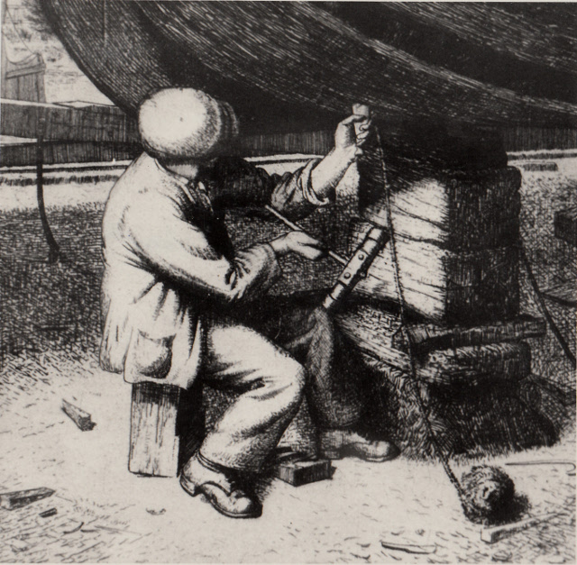
A sketch of a boatbuilder caulking a barge’s wooden planks
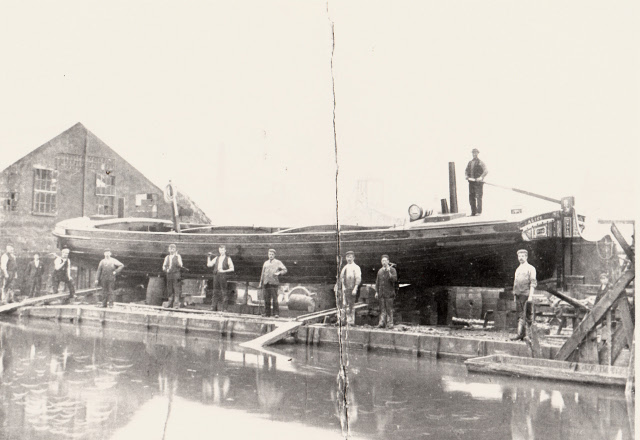
A photograph of a completed barge called Alice about to be launched with James Hodson stood on the right of the picture.
This was the last boat to be launched on the third slipway.

 Loading more