
 Loading more
History of Wilpshire Area
A History of the Wilpshire Area
by
Mike Sumner
Wilpshire today has a small portion of its area in Blackburn Borough and borders Brownhill with the rest of its area extending into the Ribble Valley towards Salesbury, Clayton-le-Dale and Langho with its highest points reaching the boundaries of Hyndburn and Sunny Bower (Blackburn). However, in ancient times, the township of Wilpshire and the hamlet of Dinkley were named together as one township with Dinkley taking up the lower slopes close to the River Ribble and Wilpshire the higher southern slopes terminating on Wilpshire Moor at 770 feet, although at other times, it came within Salesbury or Clayton-le-Dale townships.
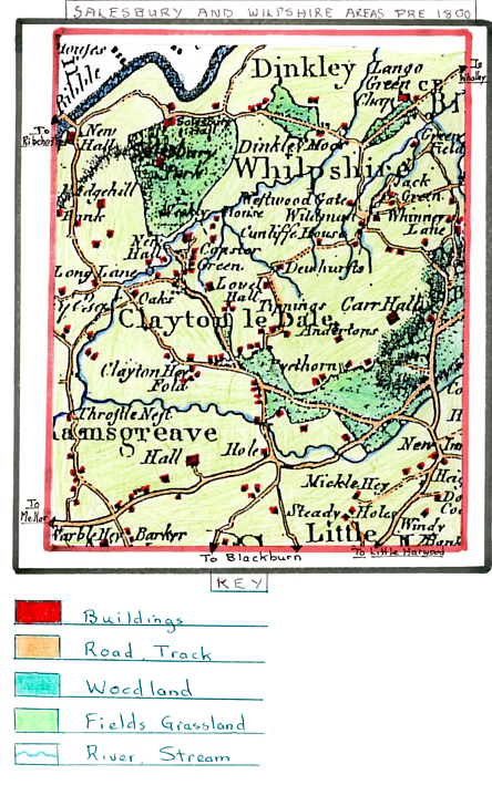
Map of the Wilpshire area 1800
Wilpshire's name has changed over time from Wlipscite (13th Century), Wlipshire (14th Century), Wylipscyre (15th/16th century), Whilipshire (17th Century) then reverting to Wilpshire in the 19th Century. Originally, the population of both areas was solely agricultural with their land consisting of meadows, pastures and heath on Wilpshire Moor. The population therefore was small and changed little but, by the 19th century, there was a noticeable reduction, for example - 1801 Wilpshire (275) and Dinkley (197), in 1851 Wilpshire (237) and Dinkley (151). This loss demonstrates how people were now starting to move to nearby Blackburn/Clitheroe areas at the start of the Textile Industrial Revolution and the reduction continued further as in 1871 Wilpshire (230) and Dinkley (119). In ancient times the township of Wilpshire was rated as ploughland of which 4 oxgangs of land lay in the hamlet of Dinkley. At the start of the 13th Century the manor was held by two theigns, namely Siward and Swain de Wlipscire, who held several freeholds and, over time, these passed to the De Hackings of Billington, Braddylls of Braddyll (sited between Billington and Dinkley where Braddyll Hall was located, which was also home to the Morleys, the Boltons and Dewhursts and Talbots whose home was at Dinkley Hall as was the Warrens. The Cunliffes and Boltons also held lands in Wilpshire in the 13th Century and it is believed that a corn mill existed during this period situated near Petty Foot Bridge at Wilpshire Bottoms. Richard de Wlipscire was living in the early 13th Century, as was Henry, whose son Adam gave the monks of Stanlow half an acre and a field of land in Wilpshire. A section of Adam's estate was acquired by the Bolton family who also held land in Salesbury. The lords of Salesbury namely the De Clyderhou, Talbots and Warrens were chief landlords in Dinkley with the Talbots also having manorial rights and lands in Wilpshire, for example, in 1432, Isabella Talbot had 4 messuages, 100 acres of land and 20 acres of meadow in Wilpshire and Dinkley. Hallhead (now called Hollowhead) estate in Wilpshire was formerly part of the Lovely Hall (Salesbury) demesne being descended from the Bolton family, their heirs and the Parkers before becoming part of Mr. E. A. Le Gendre Starkie's estate. The Dewhurst family are linked to the Wilpshire area's history as they lived in a place called Dewhurst and were seated in the township for more than four centuries. Robert De Le Dewhurst was settled here in 1277 when much of the land was owned by David De Wilpshire. William and Oliver Dewhurst were paying a subsidy levy in 1523 for lands in Wilpshire, with William also being assessed in 1570 before he died in 1592 when he bequeathed 20 shillings to Blackburn Grammar School. John Dewhurst, the son of William, was recorded as a freeholder in 1600 and taxed on his lands at Dewhurst in 1610. When William Dewhurst of Ribchester died in 1622 his lands at Dewhurst consisted of two messuages together with 60 other acres at Wilpshire, a messuage called The Ashes and 30 other acres of land tenements belonging to Sir John Talbot of Salesbury Manor with 4 shillings rent. Descendants of William continued to live in Ribchester and held lands in Wilpshire to the 1770's. Roger Dewhurst born at Dewhurst House, Wilpshire in 1720 lived in Billington, holding lands in Wilpshire and a branch of this family were seated at Micklehey, Rishton.
Another Wilpshire family were the Fieldens starting with Francis Feuilden of Pythorne and Henry Feilden paying a land subsidy tax in 1570. Later, another Henry Feilden was a governor at Blackburn Grammar School in 1628. Yeomen called Feilden include Oliver, Robert and George who died in 1721. The Kenyon family acquired importance in the Dinkley area in the 17th Century where they held lands (one messuage and 24 acres) together with land in Whalley and resided at Park Head, Whalley. This family is linked to Lloyd Kenyon born in 1732 who later became Attorney General, Master of the Rolls and Lord Chief Justice of England and was created Baron Kenyon in 1788. A further family linked to Dinkley in the 17th century are the Lansdales who, in 1873, held a freehold farm of 31.5 acres in Dinkley. A branch of the Talbot family (Lords of Salesbury Manor) are traced back to Peter Talbot who lived at Carr, Wilpshire whose son was Stephen living in 1481 and then his son George who was living in 1500. Their messuage of land had passed to the Talbots from the Cunliffes of Billington when Roger Cunliffe died and his daughter Ellen inherited it when she was married to Peter Talbot. Nicholas Talbot was taxed on lands in Wilpshire in 1523 with two messuages, 40 acres of land, 16 acres of meadow and 18 acres of woodland in Wilpshire/Salesbury. It was this family that established Carr Hall, the house being re-built during the 17th Century with a central block with projecting gabled wings, one for the family and the other for the kitchen, buttery and servants quarters and was very similar in style to many others in the Ribble Valley. It was sited in a wooded hollow on the north side of Wilpshire Moor. George Talbot's estate at Carr was sequested for 'delinquency' by Parliament in the Civil War and passed to John Braddyll. At a later date, the estate was acquired by the Petre family of Dunkenhalgh. The place name "Carr" is derived from its situation under a high bank beside a moorland stream, the word "Carr" means a piece of low boggy land. Carr Hall is sited close to the Blackburn to Whalley/Clitheroe turnpike road close to Langho with its gritstone walls for many years whitewashed and was separated from its farmyard by a garden plot (see photos below).
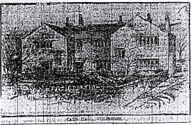
Carr Hall with front elevation and garden plot enclosed
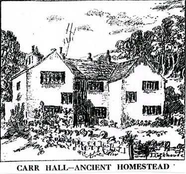
Carr Hall with its whitewashed gritstone walls showing its location in a wooded hollow
By the mid 1860's Wilpshire's population was solely employed in agriculture and was both small and stationary e.g. 1801 – 275 people and in 1881 – 280 people. However, by the early 20th century, the population rose as transport links improved, firstly by the construction of the Blackburn, Clitheroe and North Western Railway which opened in 1870, with its own station at Wilpshire, followed by the extended tramway from Blackburn Cemetery on Whalley New Road to its terminus at Wilpshire which allowed people to live on Blackburn's outskirts and travel in to work. In 1901, the population had risen to 1068 people. By this time, wealthy industrialists and professionals from Blackburn had built large villas along Whalley New Road in the Wilpshire area and countryside outside Blackburn.
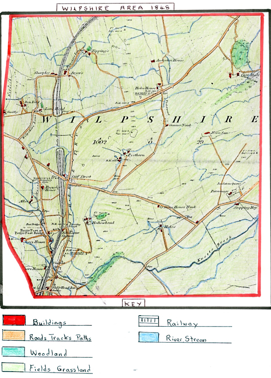
1848 Map of the Wilpshire area
The map clearly shows that in 1848 the Wilpshire area was almost totally rural, dominated by a landscape of fields/field boundaries with a few isolated areas of mixed woodland/copses. By now, the Lancashire and Yorkshire Railway had its first section running from Blackburn at Daisyfield to Whalley, Clitheroe and Chatburn and had recently completed and cut a significant route south to north on the western side of the area with the use of prominent embankments/cuttings and the Bulls Head Tunnel to maintain its course.
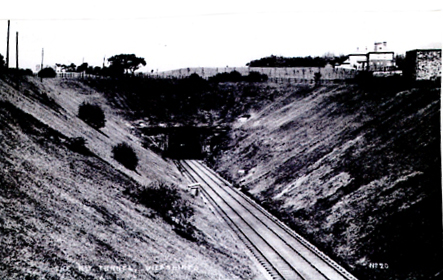
Bulls Head Tunnel Wilpshire leading from a steep cutting
The first sod for the railway was cut 30th December 1846 by Lord Ribblesdale with the lines opening properly on the 22nd June 1850, after a number of setbacks, including the Whalley Viaduct, with the Yates foundry of Blackburn making the railway line iron castings. Interestingly, the first railway station in Wilpshire is shown with a single branch line for goods which links to a track leading down from the Blackburn, Clitheroe Trust Road but is called Ribchester station clearly indicating that this was a key communication link for Ribchester village with the goods line being linked to farm produce and movement of live animals. Originally, the railway line terminated at Chatburn and was later extended to Hellifield. What we know as Whalley New Road today was then called the Blackburn, Clitheroe Trust Road (which would be a toll road) also linking Whalley and follows a similar route as today, dissecting the area. Linking to this road is Long Lane (Ribchester Road) to the west and Hollowhead Lane running to the east which links to Parsonage Road forming a major junction in the central area. Parsonage Road was formerly called Featherbed Road after Featherbed Farm which got its name from the fact the farm was home to a poultry agent to whom local farmers sold their hens and chickens. Most of the other road links are lanes or tracks running from the previously named roads to the many isolated pastoral farms in the rural landscape – e.g. Wilpshire Lane that runs from Long Lane linking the farms Ben Fold, Lane Head, Sharples, Bryers and Tippings before joining the Blackburn, Clitheroe Trust Road.
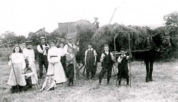
Early farm workers on a Wilpshire farm in the early 1900's at hay time
Another well known link lane ran down from the Blackburn, Clitheroe trust Road in the south just past the Bulls Head Inn under the railway where it was called Wilpshire Bottoms continuing up the hill as Knowsley Road before joining Long Lane just prior to Salesbury.
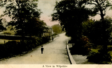
An early view of Wilpshire Bottoms after passing under the railway
This route became a popular walk when the tram service later came to Wilpshire and again has farms and farm cottages alongside it as it passes on its way over Petty Foot Bridge crossing Shawley Brook.
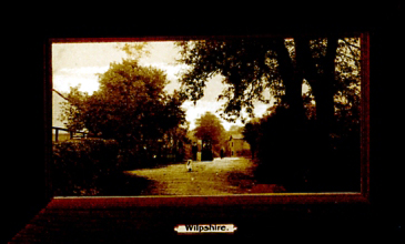
Early 1900's view of Petty Foot Bridge and Wilpshire Bottoms
The main farms at this time were all pastoral (mostly cattle and sheep) some of which formed small hamlets, included Pyethorn, Parsonage, Hollowhead, Holes, Stopping Hey and Carr Hall to the east of the trust road and Holes house, Anderton House, Tippings, Bryers, Sharples, Ben Fold, Alker, Jessy House and Knowles house to the west and north.
An interesting place name on the map is Stiff Street which ran from the Trust Road up to Pyethorn – could the name indicate the steep gradient of the track up to Pythorne? The importance of horse transport at this time is indicated by the smithy opposite the Bulls Head Inn at the boundary between Brownhill and Wilpshire and the other smithy off Wilpshire Lane and Long Lane on the Salesbury boundary. Carr Hall the ancient homestead can be seen located in a hollow on the hill side between two sizeable woodland areas which would be ideal for hunting in the early days. The Bulls Head Inn mentioned earlier on the Trust Road as it enters Wilpshire is an ancient hostelry which would have been a coaching inn for travellers on the Trust Road. Stone was an important building material at this time for the building of farmhouses and cottages in the area indicated by Parsonage Sandstone Quarry on the upper slopes of Wilpshire and a place name Stony House Nook. In the southern section of Wilpshire all the streams drain down into Shawley Brook and Knotts Brook. It is interesting to note that in the early years of the 19th century an attempt to establish an annual horse racing steeple chase was made although it ceased after a few years. In June 1839, James Forrest (Cotton manufacturer) presented a beautiful golden headed whip engraved by gentlemen who had an interest in the steeple chase and a dinner arranged that was well attended. On the 30th March 1840 the steeple chase took place at a site beyond the Bulls Head Inn, two and a half miles from Blackburn, near the Whalley road and thousands attended. Following the races a dinner was held in the Assembly Room (King Street) with Mr. Hornby (Chairman), Mr. T. Turner (Vice Chairman). On the 23rd. March 1844 the last meeting was held at Olivers on Whalley Road after which the event lapsed. Squire Hollinshead who was the main organiser caused a local poet to pen a ballad:-
“Squire Hollinshead's the sporting king and master of the horn,
His fame shall ring through future years to ages yet unknown,
When this great combat did commence thousands of people gazed,
To see this noble enterprise they truly were amazed."
However, although the races ceased at Wilpshire they continued at Tockholes and Brindle, also organised by Squire Hollinshead of Hollinshead Hall, Tockholes, who was lord of the manor there.
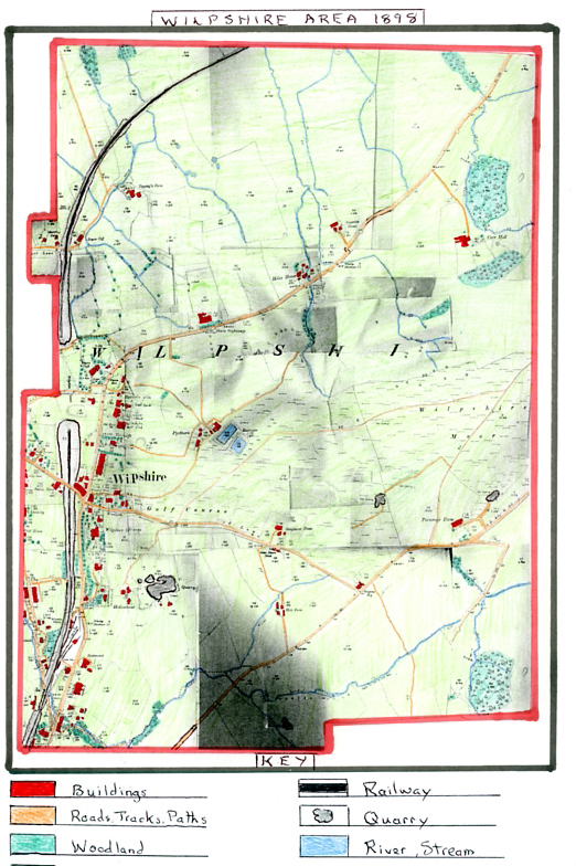
1898 Ordnance Survey Map of the Wilpshire area
The largest change over the last 50 years visible in 1898 is the large increase in housing within Wilpshire mostly in a linear development along the Blackburn to Clitheroe Trust Road, especially from Brownhill to its junction with Wilpshire Lane and along Wilpshire Bottoms/Knowsley Road. A large percentage of this development is made up of large detached houses built by wealthy industrialists (textiles) and professionals of Blackburn who chose to move to the more rural edges of the Ribble Valley where presumably land was cheaper to develop and available. Many of these residences have house names including Rockmount, Bella Vista/The Knoll, Wilpshire Grange, Woodlynn, Tacrecliffe, Ivy Bank, East Bank, Hydraston Villa, Warren Holt, Bryers Croft, Runny Bank, Knowsley, Field House, and Clayton Grange, which was destroyed by fire in 1878. The fire was caused by cotton workers during the cotton riots against its owner Colonel Jackson, a mill owner, who would not raise operatives wages (rebuilt later by another cotton magnate called Henry Ward).
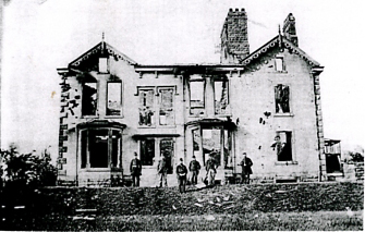
Photograph of the burnt out original Clayton Grange in 1878
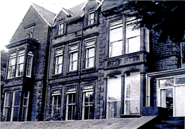
Photograph of “The Grange"
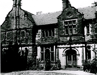
Photograph of Bryers Croft
Bryers Croft was built by Mr. Bickerdyke who was chairman of Blythes Chemical Works in Accrington around the time the Ordnance Survey map was drawn. Bella Vista (Grand View) was built for John Duckworth who owned Roe Lee Mills and was later renamed The Knoll. Over time, it was extended and had a coach house, tennis court and outdoor swimming pool together with beautifully landscaped gardens on sloping land down to Whalley new Road opposite the entrance to the old Wilpshire Railway Station from which Mr Duckworth would catch the train to Manchester.
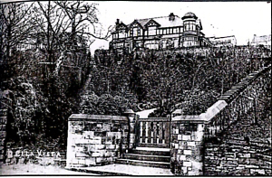
Photograph of “The Knoll" – Early 1900's
Wilpshire Grange was built by Mr. Edward Briggs in 1859 who was a cotton manufacturer in Blackburn and it was later occupied by Mr. Edgar Appleby J.P. Opposite Bryers Croft stands Warren Holt the residence of James W. Stones, J.P. and, like other neighbouring detached houses, e.g. Thorncliffe, Glendene and Hazeldene, possessed large attractive gardens. During the same period rows of terraced houses were built alongside Wilpshire Bottoms and on Whalley New Road in order to meet the growing needs of the increased local population.
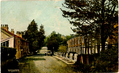
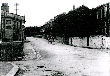
Wilpshire Bottom's terraced houses – Early 1900's Terraced houses built opposite the Wilpshire Hotel and beyond
Also, along Whalley New Road, apart from detached houses being built, larger terraced villas were built on lateral spaces found beyond the Bulls Head area along with larger semi-detached properties just beyond the terraced houses on Wilpshire Bottoms.
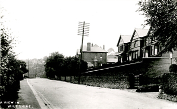
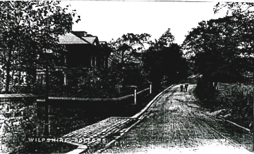
Terraced Villas on Whalley New Road Large Semi-Detached houses at Wilpshire Bottoms
At Brownhill's junction with Wilpshire, where the Bulls Head Hotel was sited and later enlarged/re-built in 1907 with stabling to the rear for passing travellers, another hostelry across the road, offering Nuttall's Ales from their Blackburn Brewery was built, called the Rising Sun, with a distinctive ornate wooden frieze round its roofline.
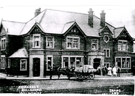
Bulls Head Hotel Wilpshire – Proprietor J.W. Parker after it was re-built
The Bull's Head Hotel was re-built and owned by Duttons Brewery which also owned the land across the road where a forge had stood for centuries and they decided to rebuild the existing forge and update it because in 1907 horse drawn vehicles still dominated so the forge had plenty of traffic from passing trade and hotel visitors.
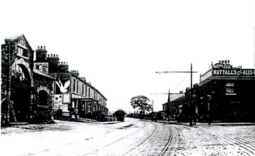
The Rising Sun Hotel with its ornate Nuttall's Ales wooden frieze,
also the newly enlarged Bull's Head Smithy across the road
and sythes propped up outside its entrance.
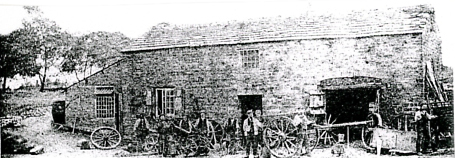
Early photo of the original Wilpshire Forge which acted as a blacksmith and wheelwright
indicated by the number of incomplete wheels, cart axis and eight workers.
It is reputed in centuries past, herds of cattle being driven to market in Blackburn were kept in a large compound at the side of the forge. The blacksmith at the turn of the century was Mr. Robinson, who was also a farmer, living at Shore house farm located across the level crossing just off the top of Knowsley Road where it drops to Wilpshire Bottoms.
Another significant change in Wilpshire since 1848 is that many of the farms have grown larger especially Carr Hall, Anderton House, Holes House, Tippings, Sharples, Stonyhouse, Pythorn and Parsonage either with extra buildings or enlarged ones probably due to increased mechanisation speeding up farm processes and the need to house machinery or extra livestock/crops or grass. At the same time, field sizes have generally grown larger due to mechanisation as new machinery was invented during this period. However, a few smaller farms on Wilpshire Moor namely Noon Star and Gunners Nook have disappeared since 1848 and their land taken over by larger farms nearby.
During the last fifty years, the railway station has grown and is now named Wilpshire station and has a more developed goods yard with two direct links to Whalley Road and an animal pen for sheep or cattle prior to loading or unloading for the use of local farms with a signal box to control access to the three sidings in the yard. One of the sidings was partly covered by a wooden shed where goods wagons could be loaded/ unloaded with protection from the weather. In the 1880's railways were the main transport used for travel to other towns and villages or distant destinations e.g. day trips to the sea-side or countryside and used to transport mail or parcels and raw materials or finished goods for local industries. In 1883, Wilpshire's stationmaster was Mr. William Haworth who lived at Station House and was well regarded in the district. As an employee of the Lancashire and Yorkshire Railway he had a key job managing this busy branch station with its staff including porters, goods clerk, signalman and general clerk. Documents found relating to the station indicate problems that arose with Pointsman Mr. Hall re' his errors in signalling causing delays to trains which had been caused by his drinking at his post and this led to his dismissal. It also appears the station was originally named Ribchester because that was the nearest settlement of any importance in 1848 as Wilpshire was just a scattered hamlet of farms and a few cottages. However, in 1870, a solicitor arriving at the station expected to find the village of Ribchester nearby and finding out how far it was threatened to sue the railway company, so, in 1874, the station name was changed. Some of the goods received or dispatched other than livestock in the 1880's included bales of cotton, shuttle tongues for textile mills in Longridge, timber, casks of petroleum, meal, oilcake from Hull, chests of tea for Ribchester Co-Op Society, eggs, skips, lime, whisky from Belfast, coal from Wigan, newspapers for delivery in Wilpshire/ Salesbury and evergreens (possibly Christmas decorations). In 1882, a gas supply reached Wilpshire from Blackburn Gasworks which meant the oil lamps in the station were replaced with gas on the platform (see photo below which shows the platforms, bridge across the lines, Station Masters House , waiting room and five staff with a shelter on the far left platform).
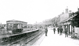
Wilpshire railway station in the early 1900's
The 1898 Ordnance Survey (O.S.) map also shows Wilpshire Golf Club had been established; the course first opened in 1890 and was located south of Hollowhead Lane and had nine holes with the clubhouse originally being the Wilpshire Hotel. In the early days, each hole was protected by a fence to keep off grazing animals with the course being moved and extended to 18 holes in 1925. By 1898, the club had built a substantial clubhouse as shown on the 1898 map.
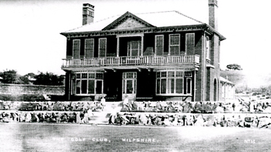
Wilpshire Golf Club Clubhouse with part of the course behind.
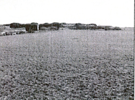
Early photo of the field where the original nine hole course was located
with a section of the present course visible in the top left corner.
Also visible on the O.S. 1898 map is Blackburn Orphanage built alongside Whalley New Road to the north, before Holes House. The Orphanage foundation stone was laid on 31st. August 1889 by Blackburn Mayor
Mr. John Rutherford but, due to a lack of funds, the building was not completed till 1891 and had its official opening on 23rd. July 1891. The Orphanage was founded by a Scottish joiner called James Dixon who began raising funds in 1886, with his life savings of £50, after finding half a dozen boys sleeping rough in the doorway of a Blackburn warehouse. James Dixon came to Blackburn from Scotland at the age of 23 to find work as a carpenter and his Presbyterian conscience led him to become a Sunday school teacher; this in turn, led him to work for the poor and destitute. Mr Dixon founded the Ragged School, providing destitute youngsters with an education before he opened the fund for the Orphanage. His friend, Thomas Hart, contributed £50 and the executors of the late Mrs. Thwaites donated £100 and, by using his contacts, he went on to raise £3700 which included many small individual contributions. This money was used to buy the land at Wilpshire and construct the Orphanage. His diary records on the 24th Jan 1889 indicate a time when he found a little boy called Peter Tomlinson with his mother asleep on some straw in an empty house in Pipemakers Entry, Furthergate. There was nothing in the house but some straw and a candle in a bottle burning near the straw. The mother was dead drunk, having sold the little boys clogs for drink. This boy was the first child admitted to the new Orphanage for boys and girls. Another child admitted was 11 year old Adolphus Curran from Duke Street who was orphaned in 1889 and had lived with his grandmother; his younger brother Arthur, joined him at the Orphanage later. Later in 1895, Adolphus went to a situation (similar to fostering) in Stanhill, Oswadtwistle and later visited the Orphanage in 1904 when he was married and living in Church. The Orphanage had to continually hold events to raise money to function including 'Pound Days' when people were asked to donate £1 in money or a pound of food. James Dixon also had the idea of sponsorship whereby people donated articles needed at the Orphanage with plaques placed on or by them with their name on it. Many people regularly donated small amounts of money which added up following various appeals to provide for the Maintenance Fund, the Building Fund and the Magazine Fund (the Orphanage produced its own magazine which helped people keep in touch with events).
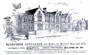
Image of the Orphanage to be built in an appeal for funds
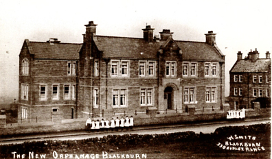
Photo of the Orphanage after it had been built and extended – early 1900's
The Orphanage building was designed by Messrs. Briggs and Wolstenholme- Blackburn Architects to accommodate 150 children with fire proof staircases and passages with iron staircases leading out from each dormitory. In the centre of the building was the administration department, a dining room and a kitchen with separate wings for boys and girls. There were separate doors for boys and girls with a playground for girls on the rear yard. The laundry and wash house were sited near the kitchen and girls department with older girls assisting in the culinary department. There was also a Superintendent's room, assembly room and bathroom/toilets in both boys and girls wings. All the rooms were well lit and ventilated with the cellar housing a boiler for internal heating. Children in the Orphanage grew up in a strict but loving regime and most would grow up to be useful members of the community
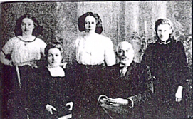
Orphanage founder James Dixon, his wife Jane and three children – Elsie, Isabella and Gertrude
James Dixon's wife Jane was an amazing character as she looked after more than 60 children besides her own three daughters and ran the Orphanage. Her death was a huge loss to the Orphanage.
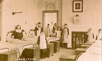
Early Photo of one of the children's dormitories
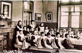
Orphanage Dining Room with the children and attendants – Early 1900's
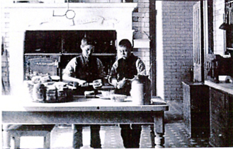 Boys working in the Orphanage kitchen
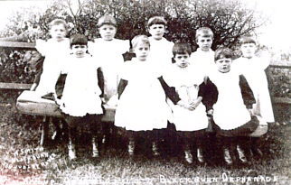 Early 1900's photograph of a group of Orphanage boys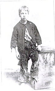
Studio Photograph of one of the earliest orphans admitted
Map evidence of the fact the Wilpshire area now had a water supply to the inhabitants is the two reservoirs sited next to Pythorn and Wilpshire Golf Club. By the turn of the century, Wilpshire also had its own Post Office with an entrance at the bottom of Hollowhead Lane opposite the Wilpshire Hotel.
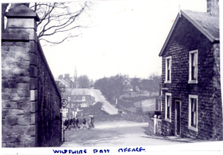
Wilpshire Post Office at the bottom of Hollowhead Lane- on the right with a group of
students from the Orphanage passing on Whalley New Road
students from the Orphanage passing on Whalley New Road