The Historical Development of Ewood and Fernhurst Areas of Blackburn
by
Mike Sumner
These two small areas, being hamlets, were originally situated outside Blackburn Borough within an area called Nether Darwen and were also connected, or held, by the nearby Livesey area for long periods. Today, these former hamlets are now merged within Blackburn with Darwen Borough, forming its suburbs. The area’s boundaries stretch from Craven Brow below the Golden Cup Inn on Bolton Road to the Aqueduct Inn and Hollin Bank area, also, alongside Bolton Road nearer Blackburn and across to the lower section of Livesey Branch Road up to the Fox and Hounds Inn. Other parts of the area reach the Ewood Aqueduct which carries the Leeds Liverpool Canal over the River Darwen forming another boundary with the nearby Mill Hill area and also stretches part way down Branch Road which runs off Bolton Road to Lower Darwen. These areas next to the townships of Blackburn and Darwen have shared their manufacturing industries over more than two hundred years.
Both areas of Ewood and Fernhurst have historical links with Celtic, Anglo-Saxon and Norman periods via their associated place names:
(1) EWOOD – this means a wood by a river (Norman).
(2) FERNHURST – is a Saxon word meaning a fern wood as originally ferns grew extensively alongside the banks of the River Darwen.
(3) RIVER DARWEN – the word Darwen is derived from a Celtic word namely Derwent which means an oak river.
(4) LIVESEY – this word is derived from the term “Leofs Island” which means an area of drier ground above a wetter river valley floor.
In the period 800-1000 A.D. areas west of the Pennines had valleys which contained large areas of wetlands alongside rivers and streams with higher moorlands, wooden sloped hill sides and extensive cleared land from early cultivation, By the end of the 11th. Century places such as Blackburn, Livesey and Darwen had emerged as distinctive communities which included Ewood and Fernhurst.
FAMILIES WHO CONTROLLED EWOOD AND FERNHURST AREAS EARLY DEVELOPMENT
(a) The original Saxon land owners acquired the areas of Nether/Lower Darwen by a Royal Grant and chose a settlement site not in the centre of the area but on the northern side of Fernhurst as it was at the foot of a hill that provided shelter. It was also close to the clear waters of the River Darwen which contained good fish stocks. The Lord of the Manor developed a Corn Mill within the area powered by a ”goyt” (a channel of water e.g. a mill- race) that operated a water wheel. This was situated in the Ewood area close to where Ewood Mill was later sited at the bottom of Livesey Branch Road. Originally the lord’s tenancy farmers owed him (suit and sake) which meant he ground their corn at his mill and then took a percentage of any profit they made from selling it. The Lord who owned the mill was now living in a manor house in nearby Fernhurst.
(b) In Norman times Nether Darwen was held together with Walton-le- Dale by ROBERT BANASTRE who was the Lord of Newton, for the service of one knight’s fee. After Robert Banastre’s family the area was divided between three other families who controlled it for almost 400 years, namely the ARDANS, the BRADSHAWS and the TALBOTS.
(c) SIR THOMAS TALBOT of Bashall who died in 1499 was Lord of the Manor of Nether Darwen on payment of a two shilling and six pence rent. His eldest son EDMUND succeeded him and his sixth son GILBERT lived in the original manor house at Fernhurst where he died in 1547. Gilbert was apparently simple-minded so his father placed him in the manor house along with the tenants who rented the house. The tenants from 1523 were JAMES and THOMAS LIVESEY from a branch of the LIVESEY family of the nearby Livesey area and the Livesey Hall. RICHARD LYVESAYE probably the son of JAMES was taxed for lands at Nether Darwen in 1570 and appears as a freeholder up to 1600.
(d) By 1598, Thomas Talbot had sold his manor including Fernhurst and Ewood areas to THOMAS WALMSLEY (Judge Walmsley) therefore the tenants of Fernhurst Manor House (the Livesey family) had to leave having lived there through the reigns of Henry V111, Mary, Elizabeth and James 1st. By the end of the 17th. Century, Fernhurst Manor House an ancient timbered structure was becoming decayed with age and though it escaped any real damage during the Civil Wars was now beyond repair. As a result, the house was re-built more solidly of stone with an extension created on its east side many years later. A stone panel on the front wall above the entrance porch had the inscription B 1700 W; the initials being those of BARTHOLMEW WALMSLEY , the squire of Dunkenhalgh, who, at that time owned the manor estate but died the following year 1701/2.
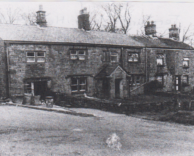 Fernhurst Manor House displaying the central porch with the panel above.
(e) Prior to the re-building of the manor house, ADAM SANDERSON had become the tenant of the house and lands as a yeoman farmer of some means, having moved here so he could combine farming and trading in local domestic textiles which outsiders learnt were becoming profitable. By 1750, Blackburn and Darwen were already noted for their textile industry via the Domestic Textile System with merchants (Chapmen) buying raw cotton, wool and flax which they stored in warehouses and was then taken out to local cottage workers who spun it into thread. The thread was passed on to hand loom weavers, also working in their homes, to weave into cloth which the Chapman bought (paid by piece) then arranged for it to be bleached before selling it on. Inventions during the 18th. Century speeded up the textile process initially with spinning and then later with the weaving process which resulted in the industry moving into large factories. Adam Sanderson was also described as a Chapman during his stay at Fernhurst, and, when he died in 1706, he was buried in Blackburn Parish Churchyard.
(f) Adam’s son, RICHARD SANDERSON, followed him as a tenant at Fernhurst and he was also described as a Chapman and Yeoman Farmer. During the time Richard and his sons WILLIAM and ADAM SANDERSON were at Fernhurst Manor House it was a favourite calling and lodging place for Non-Conformist Ministers, and also, a meeting place for their ruling Elders and Decons. The Sandersons’ were amongst a group of important laymen who supported local Non-Conformists from local churches and dispensed homely hospitality to their pastors in Lower Darwen and Tockholes as they were situated centrally from them. Richard Sanderson died in 1729 and passed on the tenancy to his eldest son WILLIAM.
(g) WILLIAM SANDERSON was the last Sanderson tenant at Fernhurst, and, with the other sons of Richard Sanderson, he started a bleaching and calico business at Ewood owning bleach and print works there which preceded the cotton spinning mill built later on the same site. An ADAM SANDERSON who died in 1757, aged 50 years, had a son, also called ADAM, who in 1778, was described as a Chapman alongside a RICHARD and GEORGE SANDERSON. The Bleach and Print Works at Ewood were advertised to be let by private contract in the Blackburn Mail of the 12th. February, 1812 along with the manor house, the Corn mill, several Print, Dry and Bleach Houses, Sheds, Barns and Stable with 54 acres of meadow/pasture land including reservoirs, sluices and rights of water adjoining the manor house now in occupation by a SAMUEL SHAW. Also put up for sale were printing blocks, utensils, tables and wash wheels used in the business together with farming utensils. The business was sited in an ideal position alongside the Turnpike Road from Blackburn to Darwen/Bolton and also located close to the Leeds Liverpool Canal and local coal pits.
(h) In 1828, MESSRS. WILLIAM AND ROBERT TURNER purchased the Fernhurst Estate from the PETRES of Dunkenhalgh, namely GEORGE PETRE of Bell House, Essex by deed. They already had extensive Calico Printing Works in nearby Mill Hill at their Stakes Hall Estate and continued in business for another 30 years. They had extended the man-made mill race from Ewood to operate their Mill Hill works at an earlier date (see my MILL HILL ARTICLE). They developed calico printing at Ewood in extended works helped by a good water supply via the mill race with a 40 foot drop in the water run from Lower Darwen Bridge to operate a water wheel and then to create steam power later using local coal. Coal mined from local seams on the northern edge of the Lancashire Coalfield is recognised in parish registers via “Coliers or Colegithers” working round the edge of Blackburn especially at Coal Pit Moor to the east of Ewood. Mining in these early days was via shafts cut down into the upper coal seams and then by tunnels inside the seams, all hand cut and the coal removed in baskets raised to the surface by ropes up the shafts. The estate the Turners purchased also included 186 acres of farmland around Fernhurst Manor Farm and several other farms including one at Bog Height whose tenants gave three days labour twice a year at shearing and harvest times in return for meat and drink at the manor farm.
(i) During 1846, the estate was sold from the will of William Turner to ECCLES SHORROCK a large textile industry magnate of Lower Darwen and the estate now consisting of 238 acres was divided into three farms namely Fernhurst, Bank Hey and Craven.
OTHER FAMILIES WITH CONNECTIONS TO EWOOD AND FERNHURST
1. An early family of Nether Darwen was that of the WADDINGTONS; RAUF WADDINGTON was taxed to a king’s subsidy in 1523 and a ROBERT WADDINGTON also paid the subsidy in 1570. Rauf Waddington died in 1597 with one messuage, 6 acres of land, 6 acres of meadow and 10 acres of pasture held of the Queen (Elizabeth 1st.) in capite. The Waddington family then moved to Upper Darwen and out of this area.
2. Another family of the area were the HAWORTHS of Hawarth who settled there in the 1500’s and appear on the Subsidy Roll in 1523 when three Haworth’s are shown as head of families in the Lower Darwen area, namely, EDMOND, PETER and RICHARD who were all assessed by the subsidy. In 1583, LAWRENCE HAWORTH of Nether Darwen provided 20 shillings to the Parish Subscription specifically to be an endowment for Blackburn Grammar School as the family had relatives in Blackburn, one of which was an original school governor (RICHARD in 1567), and, at later dates, LAWRENCE and NICHOLAS HAWORTH were also the school’s governors.
3. The HOLDEN family of Ewood had a freehold there for several generations. THOMAS HOLDEN DE EWOOD, who lived during the reign of Henry V111, had a son and heir called WILLIAM who had lands in the area in 1523 taxed to a subsidy of the time, and, in 1524, also held the lands of a GEORGE ASTLEY. THOMAS HOLDEN who was classed as a Ewood gentleman was assessed for tax in the 1570 subsidy. WILLIAM HOLDEN (the son of Thomas), also a gentleman, was a free tenant of land in the area in 1585 when he held land in tenancy from JAMES LIVESEY by a messuage called Ewode in Lyvesey which contained 20 acres of land, 10 acres of meadow and 20 acres of pasture which he had inherited together with 2 acres of moss and 6 acres of waste in Livesey. William died in 1593, and, in 1607, RANDOLF HOLDEN of Eywood was involved in a ward-ship case at the Chancery Court of Lancashire. RALF HOLDEN of Ewood, the brother of William, was shown as a freeholder in 1600 and there was also a RANDAL HOLDEN shown in the tax subsidy of 1611 who died in 1623. Ralf Holden an Eawood gentleman was involved in conveying a messuage and tenement called Eawood lying in Livesey to LAWRENCE AINSWORTH, a Tockholes gentleman, and, CHRISTOPHER MARSDEN, a yeoman farmer from Okenhurste for the benefit of WILLIAM MARSDEN and his wife MARIA. This was made up of a large dairy, a buttery, a milk-house with a kitchen and bedrooms above the north end of the house, a “Turffe” House, a Shippon, a large barn, half a dove-house, half the gardens, a stockyard and an orchard. Also included were lands from Eawood Foulde to More Yate and Little Hey with moorland nearest the house with freedom to wash and fetch water at the stream and broad water (river). WILLIAM HOLDEN died in 1630, in Charles 1st reign, when he paid a year’s rent of 12d for the messuage called Ewode with 10 acres of land, 3 acres of meadow, 3 acres of pasture together with a 3rd. part of 4 messuages and 6 acres of land in Livesey. There was also a THOMAS HOLDEN of Eawood who was a yeoman farmer who died in 1662, but, after this date, all the Holdens moved into Livesey from Ewood mostly as yeomen farmers but also as Chapmen at a later date when textiles became more important.
EARLY FEATURES OF EWOOD AND FERNHURST AREAS
TRANSPORT – Early roads through the area from Livesey, Blackburn and Darwen areas were merely tracks which were often difficult to traverse especially in winter.
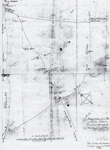 This is an early 1720 map by Whittaker of the area showing the main track routes from Blackburn
including the route later developed into a Turnpike (Bolton Road) through Ewood and Hernhirst (Fernhurst) to Darwen and BoltonThe course of Sandy Lane to Lower or Nether Darwen and up to Tockholes can also be traced. In 1797, plans were made for a new improved Turnpike Road from Blackburn, through Darwen to Bolton. This was mainly to attract potential buyers of cotton mills, calico printing shops and coal mines close to the route, as a more solid road would be a considerable advantage in the movement of heavy goods especially coal, lime and raw cotton. The trustees approved the first section of the road from Turton to Little Bolton which covered about four and a half miles. Another short section of the route was developed later from the Golden Cup Inn in Nether Darwen down Craven Brow to Ewood with the rest of the journey still to be covered on the old highway/tracks. A section through Darwen and over Bull Hill was completed in 1799 after objections held up the work. Other problems revolved from the need for side gates at junctions to stop people avoiding tolls at main toll points/gates. By the summer of 1800, the whole route was completed with the trustees in debt to the sum of £6000. In 1810, the Turnpike Act was renewed to increase revenue by increasing toll prices as its debts had risen to £10,894. However, over time the debt continued to rise up to £31,000. By 1830, tolls had to be increased again especially as overweight loads were escaping the full charges, so, new weighing machines were introduced and Toll Keepers told to be more vigilant/less lenient with the charges. Samuel Jessop the Keeper at Ewood Toll House had several problems referred to the law due to complaints regarding his toll charges. The Toll Bar at Ewood was sited near the Albion Hotel. Sometime between 1866 and the 1880’s this Toll Bar was abolished as the area became incorporated into the Borough of Blackburn with new steam tram-cars introduced between Blackburn and Darwen along a new system of tram tracks. The old saddle-back bridge over the River Darwen at Ewood was also replaced by a new wider bridge more level with Bolton Road to better accommodate the tram lines and pedestrians.
The first railway line from Blackburn to Preston was opened in 1846 which became the East Lancashire Railway Company, and later, in 1848, the Blackburn/Darwen/Bolton line passing through the Ewood/Fernhurst area was opened, and, by the 1850’s, the network became the Lancashire – Yorkshire Railway Company. These developments resulted in a reduced use of the Leeds Liverpool Canal over time.
OTHER EARLY HISTORICAL FEATURES OF THE EWOOD AND FERNHURST AREAS.
(A) The Ewood area of the past appears to have been included in the Livesey Township, and, the Fox and Hounds Inn is supposed to have originally been the private home of the people who owned and farmed the Ewood estate land which ran down to the River Darwen. Old lanes and tracks through the area have long disappeared and prior to the original hump-back Ewood bridge being constructed, early travellers had to ford the river close to where the Aqueduct Inn was built. A lane from the ford and later bridge led up from the River Darwen to the Ash Pad area which ran from lower Livesey in front of the Fox and Hounds creating a boundary line between Livesey and Lower Darwen Townships. This winding and dangerous track led up to what became Livesey Branch Road and was later replaced with a straighter road (Albion Road) connecting Bolton and Livesey Branch Roads. The early tracks were used by pack-horses carrying goods in paniers across the area, especially lime and coal. Another old lane ran alongside what later became Bolton road and then turned into Fernhurst Farm and places close to it.
(B) In the past, amateur gardeners from Ewood became renowned for winning prizes at horticultural shows both locally and, at more distant places in West Lancashire. Visitors to their plots in Ewood included Lords and Country Gentlemen who admired their cultivation techniques and wondered how they achieved such good results with fruit, vegetables and flowers via intensive cultivation. Ewood's natural situation was sheltered from cold winds, being sited on the valley floor, and this helped the gardeners greatly. As the area had originally been swampy with occasional floods from the River Darwen dropping sand, gravel and loose vegetation onto the land near the river banks there developed a rich loamy and fertile soil which was also helped by the rough herbage growing along the river banks rotting down over the years. The Leeds Liverpool Canal Embankment built across the River Darwen valley floor acted as a wind screen on the west side and the artificial man made mill- race built off the River Darwen to bring water to the Cotton Mill at Ewood and beyond in Mill Hill also created water vapour which fell on the land providing moisture during dry periods. Another factor was that in early days before the major industrial developments in the area, the air was cleaner and sunshine more direct which all aided plant growth. The garden plots were developed in sheltered nooks along the valley floor in the area close to the mill-race. Terraced houses built alongside Bolton Road opposite St. Bartholomew’s Church and School are sited on part of the ground formerly used as garden plots. At this time, there were trees lining both sides of Bolton Road from Ewood Mill to Cravens Brow.
(C) In the early 1790’s on the site of the original corn mill, JAMES HITCHEN built a small Textile Carding Mill worked by a small water wheel supplied by water from a stream running down from Bog Height. This was later taken over by ADAM SANDERSON who developed a Spinning and Carding factory there. In 1794, this was operated by E.J. and J. HAWORTH when it contained Spinning Mule Machines driven by hand. Subsequently, a Calico manufacturing and Bleach works were built at Ewood on the same site using water brought by the mill-race for power. This in turn was purchased by ROBERT and WILLIAM TURNER who for the next thirty years operated a large textile business here and in Mill Hill. In the 1830’s, the Turners enlarged Ewood textile Mill and installed Power Looms in new weaving sheds together with the Spinning Mules all powered by a water wheel. In 1843, the former printing shops were closed and used for spinning and weaving processes. At this time they also developed a mill lodge which was fed by the mill-race and provided back-up for the cotton mill during dry periods. The lodge also supplied piped water to their 59 cottages housing textile workers. By 1857, the Turners had cash-flow problems and sold Ewood Mill to Messrs. RATCLIFFE and STONES who went on to enlarge it to contain 450 looms and 23,600 spindles and continued to use the water wheel power source but also installed an additional boiler and an early Steam Engine.
(D) Ewood Aqueduct was a large stone built bridge which took the Leeds Liverpool Canal over the River Darwen being completed in 1816 as one of the last construction phases of the canal linking it to Blackburn centre. It was part of a huge earth embankment taking the canal across the River Darwen valley at the same level. In the early days a track ran under the aqueduct alongside the river from Mill Hill which later became Aqueduct Road which eventually ran over the top of the river which was covered in. The canal was an important early transport system for the first cotton mills which were usually built on or near its banks as it provided barge transport for heavy loads of coal and raw cotton and water for the mills steam power and finished goods could be dispatched along it to distant markets.
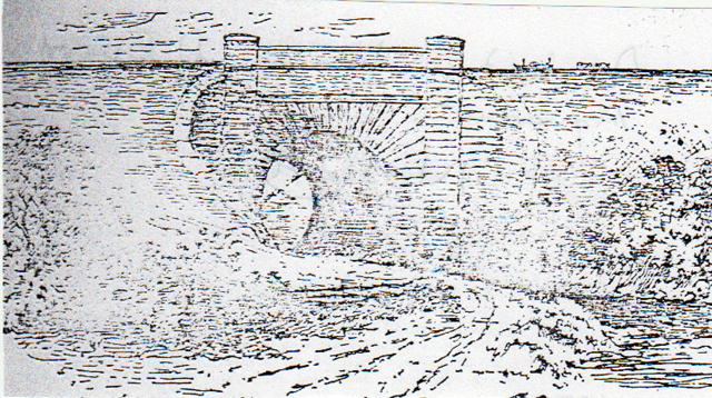 A sketch drawing of Ewood Aqueduct
(E) The use of the word “EWOOD” by its original natives varies from “Ee-wood” to
“Eawood” to “Th’eawood” and even “Yeawood”. Research shows most Blackburn people called it “Ee-wood and old natives “Th’owd”. Originally the hamlet of Ewood was called “Ewode” and then by various spellings indicated above. In 1573, it was described as “Heywood in Livesey”, and, in 1614, within a deed as “all those lands from the Eawoode Foulde”.
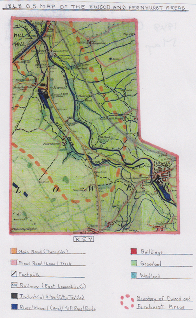 1848 Ordnance Survey map of Ewood and Fernhurst areas
This map clearly shows the two areas are predominantly rural at this time, being situated outside Blackburn and Darwen townships. The area consisted mostly of grassland much of which would be pasture of a variable quality, with wetter areas near the river together with the remnants of woodland, as the majority of earlier woodland had been removed for farming. The grassland on the higher slopes would be used for rearing sheep and the lower slopes and valley floor would be used by cattle. At this time, all the small settlement was located on the sheltered River Darwen valley floor or the lower slopes of the valley sides. Ewood had grown from isolated buildings to the earliest rows of terraced cottages built by the owners of Ewood Cotton Mill for their operatives. The owners of the mill, Robert and William Turner, operated various textile processes here, and, in Mill Hill, but, by 1848, had sold the Ewood Mill which was now using steam powered machines. Water from the man-made mill-race developed by the Turners and brought from the River Darwen helped create the steam power to drive the first mule spinning machines, and later, power looms for weaving. Also visible on the map, in nearby Lower Darwen, is the equally large THOMAS ECCLES Cotton Spinning Mill which was erected in 1774 and operated by water power first using Arkwright’s early spinning machines, and, by 1848, had developed its own mill lodge by the River Darwen and subsequently had machines running on steam power.
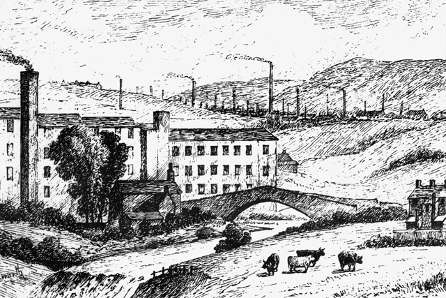 A sketch by Charles Haworth showing Lower Darwen bridge with Thomas Eccles Cotton Spinning Mill
behind with the river Darwen flowing below and Ewood/Blackburn areas in the distance.
In 1848, coal to create the steam power together with raw cotton would be brought into the area by the Leeds and Liverpool Canal and via the newly built Blackburn to Bolton railway lines; goods were taken to suitable drop-off points and transported to the mills by horse and cart. Cotton spun in the mills would pass to merchants (Putters Out/Chapmen) who would then supply local hand loom weavers in outlying weavers cottages, including farm cottages as farm workers supplemented their earnings especially in winter by hand loom weaving with the “Putter Out” collecting the finished cloth and selling it on.
At this time, larger outlying buildings visible on the map including Fernhurst Hall, Top of the Croft, Lower Hill House, Longshaw, Hollin Bank, Lower Moor Gate Fold and Cravens would all be engaged in farming the land, mostly by pastoral farming to provide produce for the local population and, for the most part, were also involved in the early textile industry. The River Darwen can be seen to receive copious water supplies via streams running down both sides of its valley, and therefore, could supply the local inhabitants water needs; piped water supplies to most homes at this time were non-existent. During the winter period, heavier rainfall could cause areas near the river to become marshy/water-logged; the evidence of flood-gates on the Mill Race indicate that flooding could be a problem. Farm animals also required water supplies hence the visible small ponds, water troughs, springs and wells on farmland to provide for their needs. The existence of a small sand pit near the Aqueduct Inn indicates that increased building at this time required building materials helped by local supplies of stone, wood and clay together with an early brick-field business in nearby Mill Hill.
Local footpaths shown on the map indicate that movement by locals was mostly by foot, or, by horse, with a ford to cross the river Darwen close to Fernhurst Hall. The main Turn-Pike road from Blackburn centre to Darwen passed through the area with a new branch road to Lower Darwen and Livesey Branch Road proving links to Preston. All of these would have carried horse-drawn traffic with Toll-Houses, sited at strategic points, to collect fees (the Ewood Toll Point) shown on the map with the letters T.P. can be seen by the side of Bolton Road before you entered Ewood Settlement. Early Inns of this period included the Aqueduct Inn, Fox and Hounds Inn and the Golden Cup Inn, at the summit of Cravens Brow, usually having some stabling facilities to cater for passing trade. As mentioned earlier in the article, gardens were created in sheltered sites on the valley floor at Ewood and Fernhurst, run by local inhabitants between the river Darwen and the mill race, where vegetables, fruit, flowers and shrubs provided food for the local people. The Ewood Aqueduct (named Darwen Aqueduct in 1848) was completed in 1816 and carried the Leeds Liverpool Canal across the valley into Blackburn. By 1848, Fernhurst Hall, sited close to the mill race and the Turnpike Road was a large detached building with two wings some of which were used to house farm animals and for storing hay. The two buildings sited close by would probably be farm cottages for its workers.
The original textile mill terraced cottages were not built to a good standard, having been built quickly to house mill operatives at Ewood, and, by the time of the Blackburn Improvement Bill of 1879, they were used as evidence to to support the bill as an example of poor housing conditions. Waste accumulated in narrow ginnels between the houses was often several feet deep (mostly consisting of ash from coal fires together with oyster shells, as oysters were a cheap staple diet for the working classes). Many of these early properties shared privies (toilets) sited in outside back areas if they existed at all. Outside toilet tubs were emptied by night-soil men into their carts, if the properties were on their system, with others left to their own ways, leading to health hazards.
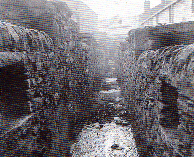
This 1879 view of a narrow ginnel between Ewood Cottages with visible waste
was typical and Ewood Mill can be seen close by in the background.
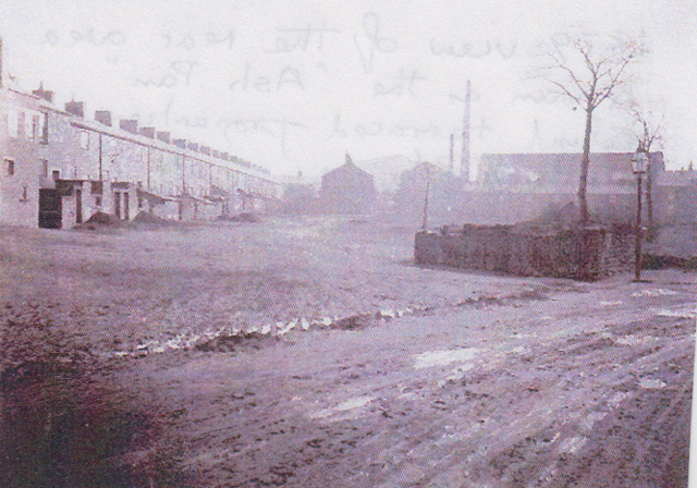
Another 1879 view of the rear area known as the “Ash Pan” behind terraced properties
on Bolton Road and Livesey Branch Road with Ewood Mill clearly visible in the background.
This land later became a car park for vehicles visiting Blackburn Rovers home games.By 1900, most privies had been removed with improved sanitation systems installed and many older stone cottages at the bottom of Livesey Branch Road close to Ewood Mill demolished and replaced by brick-built terraced properties.
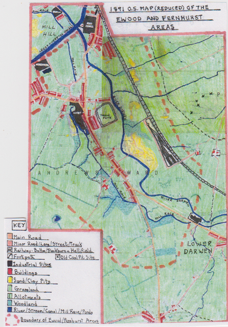
1891 Ordnance Survey Map of Ewood and Fernhurst areas
In the forty-three years since 1848 this area, sited in the River Darwen valley, shows great changes to its landscape as it entered the Victorian period, by which time, it had been incorporated into Blackburn Borough which had grown outwards, enlarging its suburbs. One major change was the large increase of the textile industry, powered by the Industrial revolution as steam powered spinning machines and power weaving looms were now widely used in large textile mills and domestic textiles had largely disappeared. As a result, Ewood Mill had greatly increased in size especially in the 1860’s when it was operated by Ratcliffe and Stones with weaving sheds added to the original spinning mill to use both processes on site.
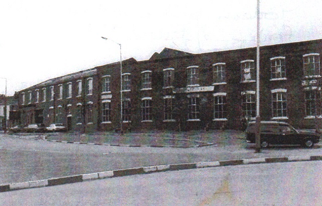 This modern picture shows the large brick built frontage of Ewood Mill alongside Bolton Road.
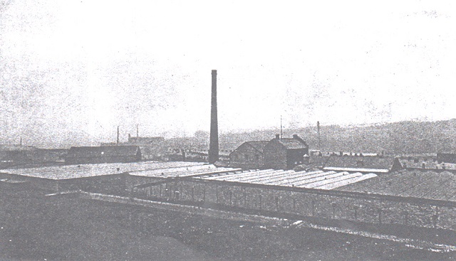
Ewood Mill which shows the extensive low weaving sheds with the higher buildings
being the older spinning mill. The tall mill chimney was common at this time
being evidence of the coal fired boilers used to create steam to drive the machinery.During the same period a huge three storey new spinning mill was built at Hollin Bank alongside the Leeds Liverpool Canal which provided easy access for heavy materials such as coal and raw cotton brought by barges and unloaded into the mills canal side loading bay. Other supplies came via Bolton road as the mill was on a site by it and also close to Bolton Road Railway Sidings. By 1891, it had also added some weaving sheds. Another large cotton spinning mill with some weaving sheds was also constructed in the Ewood area alongside the Leeds Liverpool Canal with its own large canal loading bay. This mill was called Albion Mill with its distinctive clock face on the side of the large spinning mill overlooking the lower Ewood ‘Ash- Pan’ area through which the mill-race ran to Mill Hill and had its own mill pond close by. Also in view on the map is a new and later built weaving mill built close to the mill-race in Mill Hill called Albert Mill (named after Queen Victoria’s husband). Another industrial development located close to Lower Darwen, on the edge of Fernhurst, was the Scotshaw Brook Paper Mill sited alongside the River Darwen from which it could obtain the water supplies. It could also receive the coal supplies it needed for steam power to run its machinery from the nearby railway sidings. By this time, there had been a large increase in demand from Victorian’s for paper products e.g. newspapers, post cards, writing paper and paper for business administration.
As a consequence of the increased industrial activity, especially via the increased development of the textile industry, there was a large increase in workers required to operate machinery and keep them constantly running, often, in poor conditions. This involved a large increase in female operatives alongside children, who, by this time, were often part-timers as they also had to attend school for set periods. All this led to an increased population in the area with movement significantly from outlying rural areas where increased mechanisation on farmland reduced the number of workers required. As a result, there had been a tremendous growth of brick built terraced housing within the area which can be clearly seen on the 1891 map. This growth was mostly in linear developments along new streets and existing roads especially those with main transport links such as Bolton Road, and, using the flatter sites on the valley floor. By this time, different levels of the working class had evolved and terraced houses built on the River Darwen side of Bolton road were better built, larger and with more facilities e.g. bay front windows and small front gardens. A good example of these houses is in the Fernhurst area, alongside Bolton Road stretching to Cravens Brow.
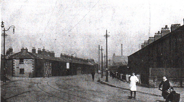
This 1890 Victorian image of Bolton Road
With its original narrow entrance into Livesey Branch Road and the sign of T. Wilson Plumber displayed on the side of a property is typical of the time. Here along the left side of Bolton Road from the junction, mentioned above, is a long row of older terraced workers cottages stretching towards Ewood Bridge. On the right side of Bolton Road can be seen newer improved terraced houses with front gardens but no front bay windows. Many of the terraced properties were rented from the textile mill owners of the area. Three young Victorian children are in view in the foreground with a young boy pushing a child in a hand-cart in typical dress of the day. Also in view, is a cyclist (now a popular mode of transport for the masses) with a horse and cart moving in the background. The mill chimneys in view are those of Mill Hill (left) and Hollin Bank Mill (right). Also visible are tramlines, as steam trams operated from Blackburn to Darwen along Bolton Road and were heavily used by the locals as a cheap mode of transport. Other items visible are ornate gas lamp standards along with tram line standard posts and the tram lines themselves in the cobbled road.
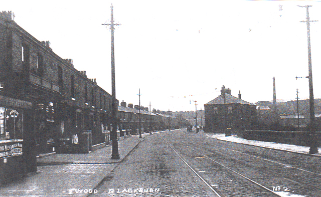
Another Victorian view along Bolton Road
Where the road enters the Ewood area with a cabin alongside the road displaying adverts of the day before, a Victorian glass fronted shop and a long row of garden fronted brick built terraced houses. On the right side of the road fenced off is part of the ‘Ash-Pan’ area (today a car park and travellers site) and the newly built Albion Hotel alongside the new access link road (Albion Road) running up to Livesey Branch Road. The tall iron standard posts on either side of the road other than street lights have been erected to take the new electric tram lines which would soon be operated. The new hotel was evidence of the need for local hostelries with the increased population in the area.
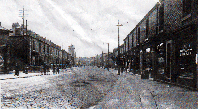
Bolton Road
Shows Ewood leading towards the Fernhurst area beyond Ewood Mill. In view on the right is a long row of glass fronted shops which provided services for the daily needs of this area’s growing population, especially foodstuffs. On the left, is a long row of newly created brick built mill terraced close to Ewood Park Football Ground. The cobbled road surface and wide pavements show improvements for both road users and pedestrians. On the left of the picture, in the distance, is the newly built St. Bartholomew’s Church and the deposits on the cobbled road surface indicate that horse drawn traffic is still important.
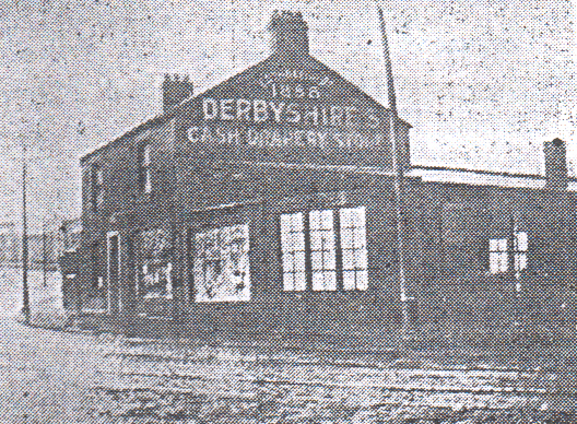 The side of Bolton Road
Where it enters Ewood shows Derbyshire’s Cash Drapery store erected in 1886 as a large retail outlet. The building was demolished in 1923 when Bolton Road was widened along with the Aqueduct (Ewood) Bridge over the River Darwen.
The 1891 map displays large clusters of newly created terraced houses around the large Hollin Bank textile mill and alongside Livesey Branch Road, close to the enlarged Ewood textile mill and the newly built Albion textile mill. Another large cluster of newly built terraced houses has appeared opposite Ewood textile mill, on the other side of Bolton Road, on land that previously had been wooded or pasture land.
By 1891, Fernhurst Hall Farm had been enlarged due to increased buildings mainly due to newly invented steam powered farm machinery being in use which required housing. This meant that fewer farm workers were required as farm tasks could now be completed at a faster rate using machinery. This is also demonstrated by the further development of Craven’s Farm close to the original Craven’s Cottage now with its outbuildings.
During this period, the road surfaces had been improved (many now cobbled with sets) and widened especially Bolton Road. The main form of public transport was now by steam powered trams with tramlines now clearly visible along the whole Blackburn to Darwen route.
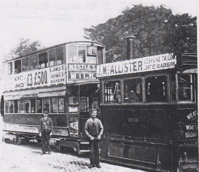
Corporation tram being pulled by a steam powered engine atWhitehall on the Darwen to Blackburn Tram route. Both of the tram vehicles are covered in advertswith the driver and conductor standing alongside on Bolton Road
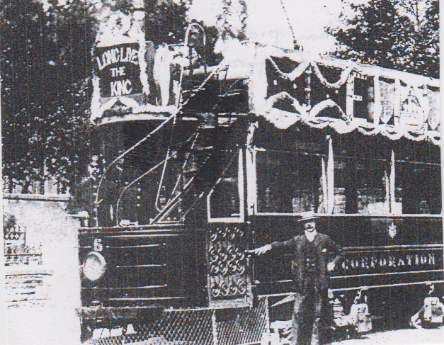 Decorated Tram in 1902
Showing a Darwen Corporation Electric Tram bedecked with bunting for the coronation of the new King Edward V11, complete with driver and conductor, as these were now being introduced to take over from the steam trams.
It was shortly after 1891 when the new electrified trams came into use, using overhead power lines supported by ornate iron standard posts, and, other than these, horse-drawn traffic and cyclists were the norm. Due to significant terraced house building many more streets had been created, and, with houses alongside them, pavements were also created or demanded. At the same time, the Blackburn to Bolton Railway line had been expanded with an extensive goods yard to cater for the needs of nearby industrial concerns together with an engine house.
On the industrial front, the 1891 map also shows a huge growth in sand and clay pit developments due mainly to the large demand for local building materials. These are visible to the east of the River Darwen and close to the railway line and new railway sidings. Pits are also shown in nearby Mill Hill. Extensive woodland areas have been removed alongside the River Darwen and Ewood Mill/Bolton Road areas to make way for workers terraced houses. As to be expected, there were now fewer footpaths due to the efficient and cheap public transport now on offer and the growth of cycling by the masses.
Sporting development in the area came about first with a large sports ground being established at Ewood in 1882 around a grass area with athletics and other sporting events staged there due to the large increase in the local population. At this time, it had no stands but a running track which was surrounded by a wooden fence with no external walls and sited on the flat floor of the River Darwen valley, close to the newly built terraced houses. In 1875, Association Football/Soccer was introduced to northern industrial area,s coming from various forms of football used by public schools and played by amateurs. As a consequence, Blackburn Rovers Football Club was formed in November 1875 when seventeen men met at the St. Leger Hotel in Blackburn. The men all came, mostly, from professional backgrounds with influence and financial backing; the club emerged from many other local football clubs to become the dominant one of the town. Its members decided to model the club colours on those of Old Malvenians (public school) who sported a quartered shirt but changed the green colour for that of a Cambridge Blue. Their first game was played at Church and reported in The Blackburn Times on the 18th. December 1875 with just four lines! At this time, the Rovers were little more than a sporting club for young gentlemen and had no ground to call their own, so, played away at other clubs who could host them. In the 1876/7 season, they bought a piece of farmland at Oozehead close to Preston New road near to St Silas Church with the backing of the towns influential business men to allow them to play games that season. However they had to use planks and turf to cover a cow-pit in the playing area. They also played games at Pleasington close to the Butlers Arms. This venue was then switched for Alexandra Meadows Cricket Ground which could hold larger numbers of spectators as the game's popularity with the masses grew. John Lewis of the Blackburn Rovers attended a meeting at the Volunteer Inn, Bromley Cross in September 1878 when the Lancashire Football Association was formed with twenty-three member clubs. In the same year, Blackburn Olympic Football Club was formed from the amalgamation of existing clubs called Black Star and James Street with the backing of Sidney Yates who had a local Iron Foundry. This meant the Rovers had a serious rival, and, in their first encounter lost. Blackburn Rovers began serious competitive football in the 1879/80 season and played in the newly formed Lancashire Cup and made their debut in the Football Association Cup. From 1879, the Rovers management began searching for better players from Scotland and increased the process by using ingenious methods to pay them illegally. This led to debates on introducing professional football into the existing amateur game. By 1880, crowds for key games were growing significantly and a game at Darwen, a fierce local rival, attracted 10,000 spectators as the working classes could now afford to pay small charges to watch games. In the 1881/2 season, the Rovers were claiming to be a premier team in England with progress and success in local cup competitions, and, at the same time, moving to a new ground at Leamington Street, which, like its previous grounds was rented for set periods. During this successful season, they won the Lancashire Cup defeating Blackburn Olympic in the final. They also reached the F.A. Cup final, facing the Old Etonians at the Kennington Oval, being the first provincial club to reach the final but lost by a narrow margin. This defeat was made worse, as the following season, Blackburn Olympic beat the Old Etonians in the final and brought the F.A. Cup back to Blackburn. However, in 1884, it was the Rovers turn to win the cup when they beat the Scottish club, Queens Park, who they went on to beat again, in the final of 1885. They won the cup again, in 1886, after a replay at Derby, beating West Bromwich Albion thus winning the cup three years in a row. In 1888, the Football League was formed, embracing professionalism, with twelve elite clubs, including the Rovers. Most of the clubs that formed this first league were from the North and Midlands and this new league introduced the demise of friendly games. The Rovers first match in the league was at the Leamington ground and was an exciting 5-5 draw against Accrington. In 1890, the Rovers won the F.A. Cup again, but, during the same year, the landlord of the Leamington Football Ground put up the rent, so, the Club decided to look for a new home. One was found in Ewood and a sum of £1000 was spent to update the Ewood Sports Ground. This ground was created in 1882 by four local tradesmen who spent the huge sum of £10,000 providing an arena for football, athletics, dog racing and trotting matches. The opening match played there was on 13th. September, 1890; the Rovers drew 0-0 with Accrington Stanley. Apparently, the Rovers had played four friendly matches previously on a site near Ewood Bridge. During the 1890/1 and 1891/2 seasons the Rovers had mixed fortunes, attaining respectable league positions with exciting cup runs to the semi-finals. Over the early years at Ewood Park there were no stands, with spectators held back behind wooden fences round the pitch. The teams changed in two wooden huts sited together with the Rovers door having their name printed on it with a lucky horse-shoe hung above the name.
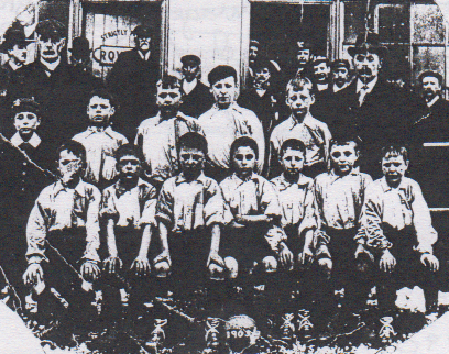
A Primary school final played at Ewood Park in the 1905/6 season
Between Emmanuel and Audley Range schools shows the Emmanuel team posing with officials in front of the changing rooms. The left hand door of the first changing room has Rovers printed on it with strictly private printed above and the lucky horse shoe hanging above the door. The changing rooms also had split glass windows looking out onto the pitch.
By 1890, the Ewood and Fernhurst area required improved educational facilities as they had grown out of existing provisions which resulted in the building of Ewood Board School by the local authority. This large Victorian building, later named St. Bartholomew’s Primary Schoo,l was built on a site adjoining where St. Bartholomew’s Church was built later alongside Bolton road just beyond Ewood Park. The school had its own play areas with a reception class and older boys and girls sections. It had links to St. Bartholomew’s earlier Christian Mission and was used for a well- attended Sunday school, and also, held mission services in its hall. The mission was overseen by the vicars of Christ Church, All Saints Church and St. Cuthbert’s Church in Darwen.
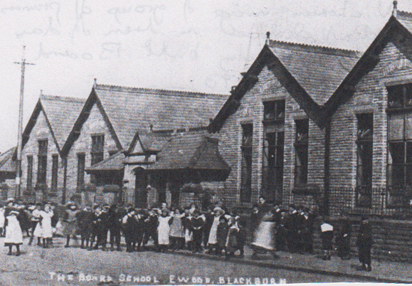 A group of primary school children
In dress of the day outside the newly built Board School in 1890 on Bolton Road.
The inns shown on the earlier map, namely the Fox and Hounds and the Golden Cup had developed to cope with the rising population. The Fox and Hounds sited at the lower end of Livesey Branch Road alongside the new link road to Bolton Road called Albion Road was adjacent to Ewood Mill and was a low two storey building.
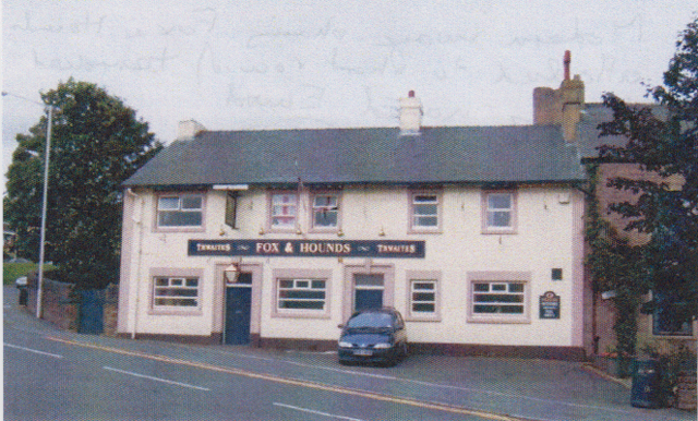 The Fox and Hounds Ewood
 Which is attached to a short row of terraced houses, named Ewood, and was the original settlement of the Ewood area. The three properties attached to it are interesting with the first a three storey property with an upper bedroom being an oddity of the row, with the end three properties clearly built at a different period/time.
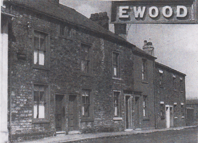
This image shows the row of properties attached to the Fox and Hounds
with the street sign of Ewood displayed on the wall which shows
where the true and original centre of Ewood is situated
The other original hostelry of 1848 namely the Aqueduct Inn sited by the River Darwen is missing from the 1891 map as it was demolished during the work to widen Ewood Bridge. It was re-built later with a distinctive dome on its frontage opposite the Ewood cinema that was also built later.
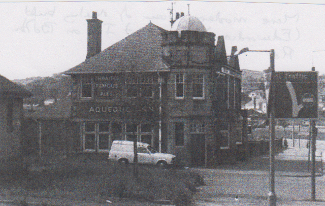
A more modern view of the newly built (Edwardian) Aqueduct Inn on Bolton Road
close to Ewood centre with its ornate upper frontage
In 1884, the Ewood and Hollin Bank Conservative Club was established’ first called just Hollin Bank Conservative Club sited alongside Bolton Road above the Empire Cinema site. This illustrates how important politics had become by this date with voting freedoms for males and with the growing population of the area due to the rise of the Textile industry here. It provided a valuable outlet similar to churches for social activities for local workers affiliated to the party such as snooker, billiards, darts, running a football team and offering bar facilities.
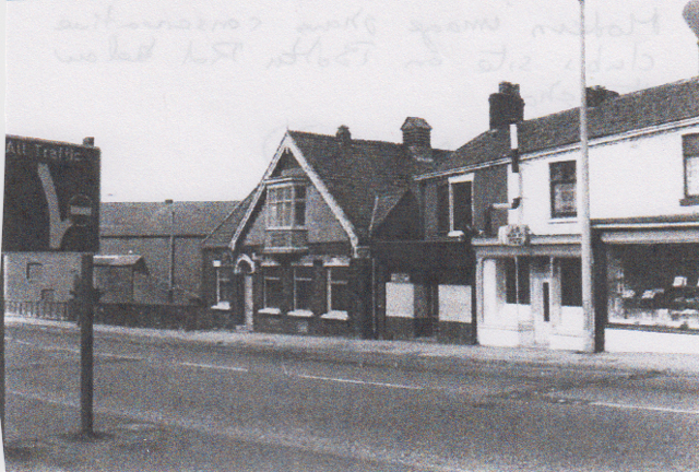 Ewood Conservative Bolton Road
 Below the shops sporting a large upper bay window offering views down on the Ewood area.
During this period as you moved through the Fernhurst area along Bolton Road rising up Craven’s Brow there were trees in view on both sides of the road.
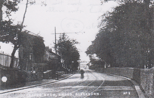 Cravens Brow
 Held behind stone walls with the distinctive tram lines in the centre and some newly built terraced houses alongside Bolton Road between Branch Road and Sandy Lane junctions.

 Loading more