
 Loading more
Some Local Place Names
Some Local Place Names
with
Plan of Blackburn in 1739
By
G.A, Stocks, M.A.
This article was written in 1908, some street names mentioned may not exist today or their names may have changed.
The modern fashion of naming streets has been adopted with a view to giving a hint as to their locality. Thus, we find in Blackburn of to-day (1908) a group of river streets such as Calder and Hodder Street. In another place we find names of trees, such as Cedar Street and Plane Street. When a town becomes big, such a nomenclature is convenient. In the plan maps of Blackburn in 1739 one may suppose that no great change had taken place for some centuries; that the fustian websters and others worked at the at the ancestral looms, and outside the town, were partly farmers and partly weavers. Some Blackburnians who have lived to see the twentieth century can recollect the trees beside the Blakewater, and the local magnate, Sudell, of Woodfold, driving down Shear Brow in his carriage and four.
In the Visitation of Henry VIII’s officers, given at the end of the Whalley Coucher Book, it is stated that all the town of Blackburn was the parson’s glebe. It was accordingly treated somewhat differently from the abbey lands. The churchyard, which originally did not extend so far south as the present church, was lined with humble cottages and a few better-built houses. One of these smaller hoses sold for £2 10s, and its yearly rent was 6d. Several “yarn-crofters” are also mentioned as paying 6d. rent. In 1687 Francis price, vicar, gives a list of poor persons who have paid 2d, 6d, and 9d, apparently as a “customary Fee” on entering into passion of the cottages. This fee was called “hearth money” by the poor. Vicar Price is firmly of opinion that none of his predecessors for a thousand years have received more from those tenants, and he avers that the houses are not more than 10s value, on average, “if set upon the rack.”
The Parliamentary survey of 1647 states, e.g., that John Sharples pays 6s 8d for a house which is worth upon the rack, per annum £4, and Jane Morris “holdeth a fair house by the school,” and pays1s 8d, the rack being in this case £1 13s 4d. it is well known that the Blackburn vicarage passed into the hands of Archbishop Cranmer, and from that time until 1847, when it apportioned to the new see of Manchester, it was a portion of the property and patronage of the Archbishop of Canterbury, situate in the province of York. Near to the Parish Church we are quite prepared to find ecclesiastical street names. Such are Cleaver Street–Cleaver was Bishop of Chester from 1788-1800. In the same neighbourhood we find Manner Sutton Street, which ought to be Manners Sutton Street, perpetuating the name of the Archbishop of Canterbury at the time of the re-building of the Parish Church, [1821-1826].
Another Archbishop of Canterbury who was previously Bishop of Chester, has given his name to Sumner Street, which lies appropriately near to Canterbury Street. The archbishop consecrated 143 churches in Lancashire only, and saw the advent of 671 new schools and 768,585 additional inhabitants in his diocese of Chester. The name Linney Yate, which is found as a name of a tenement, I think, in the Eanam neighbourhood, may remind us of old Ralph Linney vicar [of Blackburn] from 1536-1555. He retired, probably on account of his religious opinions, and lived for at least 10 years afterwards. Starkie Street reminds us of Thomas Starkie, our mathematician-vicar, 1780-1818. Syke Street probably marks the sight of an old water course. It is a familiar name, as a boundary or landmark in old documents. The Hallows, Upper and Lower, have frequently been referred to as the parcels of land that took their name from Hallows Spring. Two other springs were St Mary’s Well and Folly Well. The last named still is found as a street name, and the well itself, I am informed, exists in the cellar of one of the cottages in Follywell Street. Stony butts was a field-name somewhere between the railway station and Darwen Street. It is just possible that these butts may have been the place where the Blackburn bowmen shot at their targets, but the word “butts” is often used to describe rough hummocky ground, though we know from our own seventeenth century local literature that facilities were desired for practice with the bow.
Bastwell is a name found more or less disguised by spelling, since before the days of the Abbey at Whalley. I have seen it spelled Baddestwysel, date about 1280. Richard de Baddestwysel had a mill on or near the Blakewater, which he made over to the Abbey of Stanlaw, and in order that the water might not be intercepted on its way to the mill by any of his heirs, he gave “all his land lying in an angle, on the south side, etc., etc.” This deed is witnessed by a perfect parliament of Blackburn Grandees, De Blackburns, Fitton, Plesyngton, Billington, Livesey, Ruyssheton, Eccleshil, Grymeschagh, and others. This “angle” is interesting, because Bastwell bears the same relation to Bastwisle as Birtwell to Birtwistle. The mname ending—twisle—is held to mean an angle formed by the meeting of two streams of water. The word is derived from the same root as twi, two, twixt, etc. Thus, a Twig denotes the fork or angle of a tree, where the small shoot leaves the larger branch. This explains the first t in names like Oswaldtwistle, Entwistle. And son on. The second t is introduced upon a false analogy with “whistle.”
Oozehead and Oozebooth, seem to denote watery places, like the name Ouse, which is so common among rivers. “Booth,” like the Highland “bothy,” denotes a small homestead. In Rossendale the whole valley was covered with such tenements, and the termination “booth” is found frequently today. Abram shows how (p. 119 A History of Blackburn) “a husbandman by a by-name called Duke of the Banks” gave his name to that part of the road called Duke’s Brow. The same account mentions the old Tithe Barn at the N.W. crossing of Duke’s Brow and Revidge as being used to shelter “Priest, Jesuits and Papists” on the occasion of that fighting which is described in the place cited. Mill Lane marks the approach to a mill on the Blakewater. The mill was the property of the family of Baron “of the Mylne” for two three centuries. The small “cut” from the larger stream which entered it again near St. Peter’s Church, is marked on the maps as “the Goit.) Jubilee Street and George StreetWest, close by it remind us of the year 1610, the jubilee of King George III. Nab lane tells of a family called Nab or Nabb, whose names occurs sellers of wine and other things in the church in the churchwardens’ account books. Fish Lane perhaps Dandy Walk and Freckleton Street recall names of owners of property.
The 1739 map shows a “Dog Cannell” on the south of the town and a “Catchem” Inn on the Bolton Road. Other interesting inn names are the “Bird in Hand,” is this a reference to the days of Hawking? “General Wolfe,” “Paganini” in Northgate, “The Old Ring o’ Bells,” “Flying Angel,” The Higher Sun,” “The Legs of Man” in Darwen Street. This was probably a compliment to the Derby family, in whose coat of arms, as Lords of man, this device had a place. Negro’s Row is spoken of as a part of our town in the 19th century. “The Ould Cockpit” has been referred previously. “Lobs o’ th’ Nook” and “Lotty’s” are names of two old tenements. The former is marked in Shadsworth; the latter is connected with the family name of Tomlinson. “Blakeley” Moor is found, and I have heard the “Blakely” pronunciation quite lately. On the Mellor side of the latest Blackburn there is a farm called “Dick Dadd’s.” The burial register at the parish church shows us that the wife of Richard Sharples de Mellor, “Dicke Dadd,” was buried in February, 1622.
For a finale, is it possible that our “Wrangling” can be the old-time wrestling ground? As a matter of etymology, it is a fairly safe derivation. Perhaps some lover of our town and its ancient divisions will oblige. The name Revidge still remains unexplained, for neither “Rough Edge” or “Ridge” seem to carry conviction as a solution of the puzzle, though the parish history of Ribchester states that “edge” is a common name for a hill on this side of the Ribble.
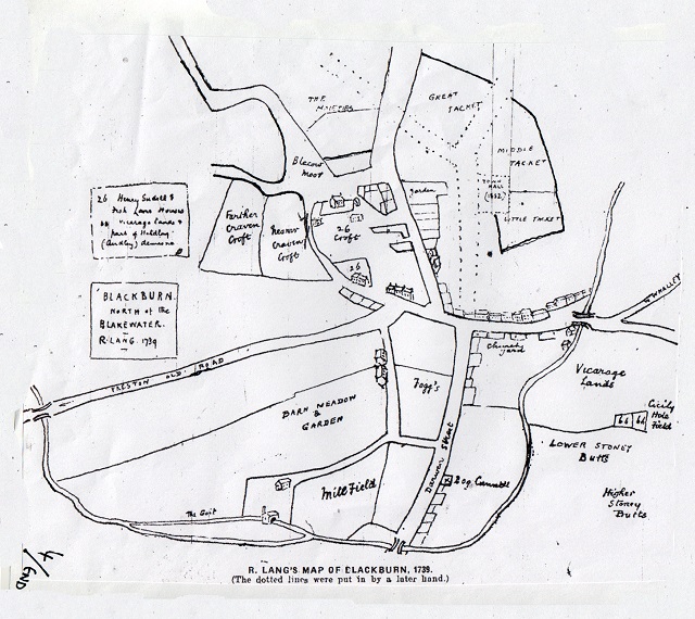
Lang's Plan of Blackburn in 1739